

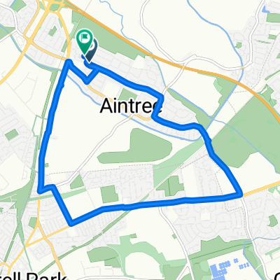
East Lancs/Rainford By Pass
A cycling route starting in Melling, England, United Kingdom.
Overview
About this route
- -:--
- Duration
- 33.1 km
- Distance
- 68 m
- Ascent
- 71 m
- Descent
- ---
- Avg. speed
- ---
- Max. altitude
Route quality
Waytypes & surfaces along the route
Waytypes
Cycleway
14.8 km
(45 %)
Road
8.5 km
(26 %)
Surfaces
Paved
17 km
(51 %)
Unpaved
0.4 km
(1 %)
Asphalt
16.4 km
(50 %)
Paved (undefined)
0.6 km
(2 %)
Continue with Bikemap
Use, edit, or download this cycling route
You would like to ride East Lancs/Rainford By Pass or customize it for your own trip? Here is what you can do with this Bikemap route:
Free features
- Save this route as favorite or in collections
- Copy & plan your own version of this route
- Sync your route with Garmin or Wahoo
Premium features
Free trial for 3 days, or one-time payment. More about Bikemap Premium.
- Navigate this route on iOS & Android
- Export a GPX / KML file of this route
- Create your custom printout (try it for free)
- Download this route for offline navigation
Discover more Premium features.
Get Bikemap PremiumFrom our community
Other popular routes starting in Melling
 Melling Loop
- Distance
- 10.1 km
- Ascent
- 24 m
- Descent
- 24 m
- Location
- Melling, England, United Kingdom
 East Lancs/Rainford By Pass
- Distance
- 33.1 km
- Ascent
- 68 m
- Descent
- 71 m
- Location
- Melling, England, United Kingdom
 22 Radley Drive, Liverpool to 23 Radley Drive, Liverpool
- Distance
- 9.8 km
- Ascent
- 29 m
- Descent
- 31 m
- Location
- Melling, England, United Kingdom
 23 Radley Drive, Liverpool to 24 Radley Drive, Liverpool
- Distance
- 8.3 km
- Ascent
- 12 m
- Descent
- 37 m
- Location
- Melling, England, United Kingdom
 Wango Lane, Liverpool to 31 Sandy Lane, Liverpool
- Distance
- 20.7 km
- Ascent
- 12 m
- Descent
- 20 m
- Location
- Melling, England, United Kingdom
 Liverpool to Keir Hardie Avenue 95
- Distance
- 5.5 km
- Ascent
- 13 m
- Descent
- 3 m
- Location
- Melling, England, United Kingdom
 26 Alscot Ave, Liverpool to 26 Alscot Ave, Liverpool
- Distance
- 42.3 km
- Ascent
- 0 m
- Descent
- 19 m
- Location
- Melling, England, United Kingdom
 49 Altway, Liverpool to 24 Radley Drive, Liverpool
- Distance
- 8.7 km
- Ascent
- 35 m
- Descent
- 45 m
- Location
- Melling, England, United Kingdom
Open it in the app