

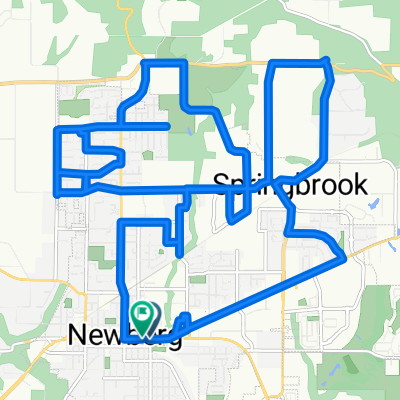
Vineride 100 mile route (2010)
A cycling route starting in Newberg, Oregon, United States.
Overview
About this route
- -:--
- Duration
- 163.7 km
- Distance
- 462 m
- Ascent
- 465 m
- Descent
- ---
- Avg. speed
- ---
- Max. altitude
Route quality
Waytypes & surfaces along the route
Waytypes
Road
72 km
(44 %)
Quiet road
13.1 km
(8 %)
Surfaces
Paved
73.6 km
(45 %)
Asphalt
52.4 km
(32 %)
Paved (undefined)
19.6 km
(12 %)
Continue with Bikemap
Use, edit, or download this cycling route
You would like to ride Vineride 100 mile route (2010) or customize it for your own trip? Here is what you can do with this Bikemap route:
Free features
- Save this route as favorite or in collections
- Copy & plan your own version of this route
- Split it into stages to create a multi-day tour
- Sync your route with Garmin or Wahoo
Premium features
Free trial for 3 days, or one-time payment. More about Bikemap Premium.
- Navigate this route on iOS & Android
- Export a GPX / KML file of this route
- Create your custom printout (try it for free)
- Download this route for offline navigation
Discover more Premium features.
Get Bikemap PremiumFrom our community
Other popular routes starting in Newberg
 404 Brandon Dr, Newberg to 400 Brandon Dr, Newberg
- Distance
- 11.6 km
- Ascent
- 86 m
- Descent
- 85 m
- Location
- Newberg, Oregon, United States
 Draft Route
- Distance
- 7.2 km
- Ascent
- 69 m
- Descent
- 62 m
- Location
- Newberg, Oregon, United States
 Wine & Food
- Distance
- 19.6 km
- Ascent
- 80 m
- Descent
- 77 m
- Location
- Newberg, Oregon, United States
 new123
- Distance
- 26.8 km
- Ascent
- 201 m
- Descent
- 196 m
- Location
- Newberg, Oregon, United States
 Champoeg loop #1
- Distance
- 13.1 km
- Ascent
- 113 m
- Descent
- 126 m
- Location
- Newberg, Oregon, United States
 St Paul Loop
- Distance
- 29.4 km
- Ascent
- 117 m
- Descent
- 117 m
- Location
- Newberg, Oregon, United States
 Vineride 100 mile route (2010)
- Distance
- 163.7 km
- Ascent
- 462 m
- Descent
- 465 m
- Location
- Newberg, Oregon, United States
 N VALLEY Loop
- Distance
- 9.5 km
- Ascent
- 59 m
- Descent
- 57 m
- Location
- Newberg, Oregon, United States
Open it in the app