

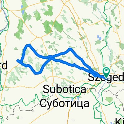
Mórakör
A cycling route starting in Szeged, Csongrád megye, Hungary.
Overview
About this route
Szentmihálytelekre használható kerékpárút vezet, amely egy szintén használható, a főúttal párhuzamos szervizútba torkollik (végig bringatilos van). Szentmihálytelek után egészen a Röszke vége tábláig sajnos igen silány a burkolat, és utána Mórahalomig is csak közepes a minőség. Ennek a szakasznak egyetlen előnye az igen ritka forgalom. Mórahalmon a körforgalom melletti tér sarkában találsz ivókutat, utána pedig a megszokott gyér forgalom mellett és a közepesen jó aszfalton lehet gurulni Bordányig. Innentől egészen Szegedig tökéletes a közút, a forgalom pedig közepes.
- -:--
- Duration
- 48.7 km
- Distance
- 18 m
- Ascent
- 19 m
- Descent
- ---
- Avg. speed
- ---
- Max. altitude

Route highlights
Points of interest along the route

Point of interest after 22.6 km
ivókút
Continue with Bikemap
Use, edit, or download this cycling route
You would like to ride Mórakör or customize it for your own trip? Here is what you can do with this Bikemap route:
Free features
- Save this route as favorite or in collections
- Copy & plan your own version of this route
- Sync your route with Garmin or Wahoo
Premium features
Free trial for 3 days, or one-time payment. More about Bikemap Premium.
- Navigate this route on iOS & Android
- Export a GPX / KML file of this route
- Create your custom printout (try it for free)
- Download this route for offline navigation
Discover more Premium features.
Get Bikemap PremiumFrom our community
Other popular routes starting in Szeged
 Maros menti nosztalgia, gyakran földúton...
- Distance
- 79.1 km
- Ascent
- 407 m
- Descent
- 446 m
- Location
- Szeged, Csongrád megye, Hungary
 szeged-hajós
- Distance
- 215 km
- Ascent
- 136 m
- Descent
- 137 m
- Location
- Szeged, Csongrád megye, Hungary
 Szeged - Töltésen Baks - Ópusztaszer - Szeged
- Distance
- 74.7 km
- Ascent
- 110 m
- Descent
- 103 m
- Location
- Szeged, Csongrád megye, Hungary
 Szeged - Ferencszállás - Szeged
- Distance
- 16.3 km
- Ascent
- 13 m
- Descent
- 13 m
- Location
- Szeged, Csongrád megye, Hungary
 Tisza Maraton útvonal terv 2011 Közép
- Distance
- 61.2 km
- Ascent
- 52 m
- Descent
- 51 m
- Location
- Szeged, Csongrád megye, Hungary
 Szegedi bóklászás
- Distance
- 68 km
- Ascent
- 41 m
- Descent
- 41 m
- Location
- Szeged, Csongrád megye, Hungary
 80km szeged
- Distance
- 82.6 km
- Ascent
- 62 m
- Descent
- 64 m
- Location
- Szeged, Csongrád megye, Hungary
 Mélypont kör
- Distance
- 35.7 km
- Ascent
- 109 m
- Descent
- 115 m
- Location
- Szeged, Csongrád megye, Hungary
Open it in the app