
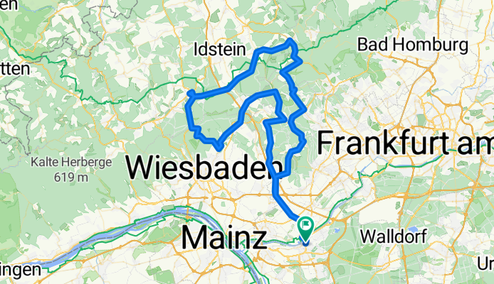
Höhenmeter sammeln ab Rüsselsheim
A cycling route starting in Rüsselsheim am Main, Hesse, Germany.
Overview
About this route
An attempt to accumulate as many altitude meters as possible with the least amount of km to be fit for truly hilly routes. According to Garmin about 2000 meters of elevation, according to Bikemap (normalized via the map) a few meters less. The ascent to Platte is paved, but still to be used with caution due to potholes caused by agricultural vehicles. Otherwise, it’s all rural road. Maximum gradient at Schlossborn > Ruppertshain is about 15%. At Lorsbach > Langenhein peaks briefly at 20%. Otherwise, it hovers between 6 and 10%. If anyone can gather more elevation from Rüsselsheim over about 100 km, please get in touch!
- -:--
- Duration
- 102.9 km
- Distance
- 1,245 m
- Ascent
- 1,246 m
- Descent
- ---
- Avg. speed
- ---
- Max. altitude
Route quality
Waytypes & surfaces along the route
Waytypes
Quiet road
14.4 km
(14 %)
Track
11.3 km
(11 %)
Surfaces
Paved
62.8 km
(61 %)
Unpaved
5.1 km
(5 %)
Asphalt
60.7 km
(59 %)
Gravel
3.1 km
(3 %)
Continue with Bikemap
Use, edit, or download this cycling route
You would like to ride Höhenmeter sammeln ab Rüsselsheim or customize it for your own trip? Here is what you can do with this Bikemap route:
Free features
- Save this route as favorite or in collections
- Copy & plan your own version of this route
- Split it into stages to create a multi-day tour
- Sync your route with Garmin or Wahoo
Premium features
Free trial for 3 days, or one-time payment. More about Bikemap Premium.
- Navigate this route on iOS & Android
- Export a GPX / KML file of this route
- Create your custom printout (try it for free)
- Download this route for offline navigation
Discover more Premium features.
Get Bikemap PremiumFrom our community
Other popular routes starting in Rüsselsheim am Main
 Rüsselsheim - Rheinterasse
- Distance
- 52.8 km
- Ascent
- 265 m
- Descent
- 268 m
- Location
- Rüsselsheim am Main, Hesse, Germany
 Kleine Opel Tour (Permanente RTF, RV Opel Rüsselsheim)
- Distance
- 49.7 km
- Ascent
- 75 m
- Descent
- 78 m
- Location
- Rüsselsheim am Main, Hesse, Germany
 Flughafen-Trip_1
- Distance
- 38.8 km
- Ascent
- 103 m
- Descent
- 101 m
- Location
- Rüsselsheim am Main, Hesse, Germany
 Mönchbruchrunde
- Distance
- 17.9 km
- Ascent
- 82 m
- Descent
- 77 m
- Location
- Rüsselsheim am Main, Hesse, Germany
 Kleine gemütliche Runde um die Opelstadt
- Distance
- 31.5 km
- Ascent
- 182 m
- Descent
- 183 m
- Location
- Rüsselsheim am Main, Hesse, Germany
 Taunus Rheingau Fahrt (Permanente RTF, RV Opel Rüsselsheim)
- Distance
- 79.2 km
- Ascent
- 768 m
- Descent
- 743 m
- Location
- Rüsselsheim am Main, Hesse, Germany
 Regional-Park-Tour rund um Rüsselsheim
- Distance
- 54.5 km
- Ascent
- 129 m
- Descent
- 129 m
- Location
- Rüsselsheim am Main, Hesse, Germany
 Lange Route
- Distance
- 28.1 km
- Ascent
- 76 m
- Descent
- 73 m
- Location
- Rüsselsheim am Main, Hesse, Germany
Open it in the app