

MTB - Tesino Bike - Celado 2301
A cycling route starting in Castello Tesino, Trentino-Alto Adige, Italy.
Overview
About this route
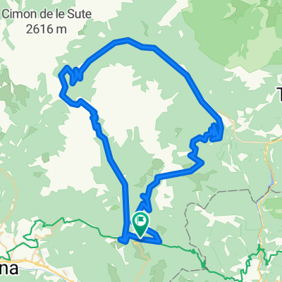
Percorso di circa 15 km che da Castello Tesino sale per strade forestali fino sull'altopiano di Celado, I primi km sono un pò in salita poi il resto si sviluppa con dei dolci sali e scendi per ammirare appieno questo magico luogo. Per il rientro si scende sempre su strada forestale che ci riporta al punto di partenza.
- 5 h 44 min
- Duration
- 15.2 km
- Distance
- 913 m
- Ascent
- 913 m
- Descent
- 2.7 km/h
- Avg. speed
- ---
- Avg. speed

Continue with Bikemap
Use, edit, or download this cycling route
You would like to ride MTB - Tesino Bike - Celado 2301 or customize it for your own trip? Here is what you can do with this Bikemap route:
Free features
- Save this route as favorite or in collections
- Copy & plan your own version of this route
- Sync your route with Garmin or Wahoo
Premium features
Free trial for 3 days, or one-time payment. More about Bikemap Premium.
- Navigate this route on iOS & Android
- Export a GPX / KML file of this route
- Create your custom printout (try it for free)
- Download this route for offline navigation
Discover more Premium features.
Get Bikemap PremiumFrom our community
Other popular routes starting in Castello Tesino
 Etappe 2 Castello Tesino - Val Canzoi
- Distance
- 73.3 km
- Ascent
- 1,335 m
- Descent
- 1,551 m
- Location
- Castello Tesino, Trentino-Alto Adige, Italy
 CT 5 Croci körtúra
- Distance
- 75.4 km
- Ascent
- 2,165 m
- Descent
- 2,165 m
- Location
- Castello Tesino, Trentino-Alto Adige, Italy
 10. Etappe Feltre, Italien
- Distance
- 48.9 km
- Ascent
- 245 m
- Descent
- 1,000 m
- Location
- Castello Tesino, Trentino-Alto Adige, Italy
 10-08-2011 13.305Km
- Distance
- 13.3 km
- Ascent
- 528 m
- Descent
- 561 m
- Location
- Castello Tesino, Trentino-Alto Adige, Italy
 Tag 6
Tag 6- Distance
- 153.5 km
- Ascent
- 219 m
- Descent
- 1,052 m
- Location
- Castello Tesino, Trentino-Alto Adige, Italy
 Giro Lavina
- Distance
- 145.3 km
- Ascent
- 3,264 m
- Descent
- 3,249 m
- Location
- Castello Tesino, Trentino-Alto Adige, Italy
 CastelloTesino-MonteAgaro
- Distance
- 29.3 km
- Ascent
- 1,284 m
- Descent
- 1,288 m
- Location
- Castello Tesino, Trentino-Alto Adige, Italy
 Passo Brocon
- Distance
- 42.6 km
- Ascent
- 1,058 m
- Descent
- 1,261 m
- Location
- Castello Tesino, Trentino-Alto Adige, Italy
Open it in the app