

Garmisch-Gardasee Etappe 4
A cycling route starting in Merano, Trentino-Alto Adige, Italy.
Overview
About this route
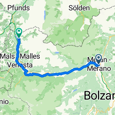
Start: Camping Meran, Etschtalradweg Richung Lana, durch den Ort auf die Gampenstraße. Über den Gampenpass nach Fondo. Auf westlicher Seite des Val di Non bis Revò. Über Cagno zum nördlichsten Zipfel des Lago di Santa Giustina (Wunderschöner Blick!). Danach durch das Val di Sole auf dem Radweg Richtung Passo Tonale. Radweg bis Dimaro folgen => Camping Dolomiti.
- -:--
- Duration
- 75.5 km
- Distance
- 1,553 m
- Ascent
- 1,058 m
- Descent
- ---
- Avg. speed
- ---
- Max. altitude
Route quality
Waytypes & surfaces along the route
Waytypes
Busy road
46 km
(61 %)
Cycleway
10.7 km
(14 %)
Surfaces
Paved
52.4 km
(69 %)
Asphalt
50.9 km
(67 %)
Paved (undefined)
1.4 km
(2 %)
Continue with Bikemap
Use, edit, or download this cycling route
You would like to ride Garmisch-Gardasee Etappe 4 or customize it for your own trip? Here is what you can do with this Bikemap route:
Free features
- Save this route as favorite or in collections
- Copy & plan your own version of this route
- Sync your route with Garmin or Wahoo
Premium features
Free trial for 3 days, or one-time payment. More about Bikemap Premium.
- Navigate this route on iOS & Android
- Export a GPX / KML file of this route
- Create your custom printout (try it for free)
- Download this route for offline navigation
Discover more Premium features.
Get Bikemap PremiumFrom our community
Other popular routes starting in Merano
 Montag
- Distance
- 77.6 km
- Ascent
- 1,713 m
- Descent
- 512 m
- Location
- Merano, Trentino-Alto Adige, Italy
 07_Mals-Meran_13-310_SchlossTirol
- Distance
- 12.6 km
- Ascent
- 331 m
- Descent
- 332 m
- Location
- Merano, Trentino-Alto Adige, Italy
 Zum Talbauer hoch über Meran
- Distance
- 27.5 km
- Ascent
- 1,021 m
- Descent
- 1,023 m
- Location
- Merano, Trentino-Alto Adige, Italy
 meran - timmelsjoch
- Distance
- 52.1 km
- Ascent
- 2,241 m
- Descent
- 68 m
- Location
- Merano, Trentino-Alto Adige, Italy
 Alpenüberquerung 4/5 Meran - Cles
- Distance
- 54 km
- Ascent
- 1,385 m
- Descent
- 1,044 m
- Location
- Merano, Trentino-Alto Adige, Italy
 Day5: Merano to Klausen
- Distance
- 70.8 km
- Ascent
- 1,665 m
- Descent
- 821 m
- Location
- Merano, Trentino-Alto Adige, Italy
 Meran_Mölten_Meran
- Distance
- 58 km
- Ascent
- 1,930 m
- Descent
- 1,219 m
- Location
- Merano, Trentino-Alto Adige, Italy
 Via Claudia Augusta 6. Merano - Terlano
- Distance
- 22.8 km
- Ascent
- 104 m
- Descent
- 296 m
- Location
- Merano, Trentino-Alto Adige, Italy
Open it in the app