

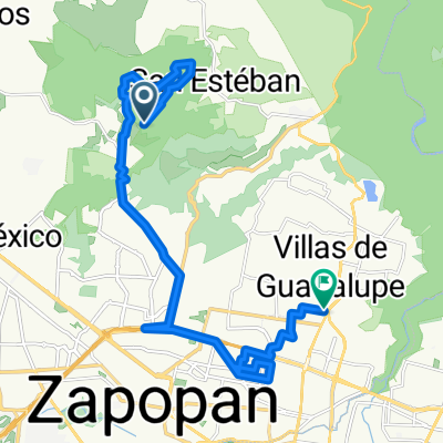
De Privada El Acantilado 3, Zapopan a Privada El Acantilado, Zapopan
A cycling route starting in San Esteban (San Miguel Tateposco), Jalisco, Mexico.
Overview
About this route
- 42 min
- Duration
- 7.3 km
- Distance
- 166 m
- Ascent
- 160 m
- Descent
- 10.5 km/h
- Avg. speed
- ---
- Max. altitude

Continue with Bikemap
Use, edit, or download this cycling route
You would like to ride De Privada El Acantilado 3, Zapopan a Privada El Acantilado, Zapopan or customize it for your own trip? Here is what you can do with this Bikemap route:
Free features
- Save this route as favorite or in collections
- Copy & plan your own version of this route
- Sync your route with Garmin or Wahoo
Premium features
Free trial for 3 days, or one-time payment. More about Bikemap Premium.
- Navigate this route on iOS & Android
- Export a GPX / KML file of this route
- Create your custom printout (try it for free)
- Download this route for offline navigation
Discover more Premium features.
Get Bikemap PremiumFrom our community
Other popular routes starting in San Esteban (San Miguel Tateposco)
 diente
- Distance
- 24.7 km
- Ascent
- 604 m
- Descent
- 702 m
- Location
- San Esteban (San Miguel Tateposco), Jalisco, Mexico
 Con el David
- Distance
- 22.3 km
- Ascent
- 439 m
- Descent
- 415 m
- Location
- San Esteban (San Miguel Tateposco), Jalisco, Mexico
 De Camino a la Presa 1195, Río Blanco a Calle San Rafael 406, Nuevo México
- Distance
- 22.2 km
- Ascent
- 403 m
- Descent
- 370 m
- Location
- San Esteban (San Miguel Tateposco), Jalisco, Mexico
 Serpent, Zapopan a Traversée de la Montagne, Zapopan
- Distance
- 3.6 km
- Ascent
- 43 m
- Descent
- 64 m
- Location
- San Esteban (San Miguel Tateposco), Jalisco, Mexico
 De Privada El Acantilado 3, Zapopan a Privada El Acantilado, Zapopan
- Distance
- 7.3 km
- Ascent
- 166 m
- Descent
- 160 m
- Location
- San Esteban (San Miguel Tateposco), Jalisco, Mexico
 De Avenida Hidalgo a Calle Vasco de Quiroga
- Distance
- 13.3 km
- Ascent
- 262 m
- Descent
- 228 m
- Location
- San Esteban (San Miguel Tateposco), Jalisco, Mexico
 Copala
- Distance
- 36 km
- Ascent
- 745 m
- Descent
- 748 m
- Location
- San Esteban (San Miguel Tateposco), Jalisco, Mexico
 Ruta desde Circuito de la Calesa 115–119, Zapopan
- Distance
- 2.1 km
- Ascent
- 0 m
- Descent
- 10 m
- Location
- San Esteban (San Miguel Tateposco), Jalisco, Mexico
Open it in the app