

Col to Harwich loop46
A cycling route starting in Colchester, England, United Kingdom.
Overview
About this route
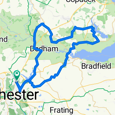
A mostly rural route with some low undulating hills. Starting in the town of Colchester heading out to Ardleigh, then on to Mistley. Here you pick up the road alongside the River Stour down to Old Harwich. From here you loop back and follow the National Cycle Route 51 back to Colchester
- -:--
- Duration
- 74.4 km
- Distance
- 235 m
- Ascent
- 235 m
- Descent
- ---
- Avg. speed
- ---
- Max. altitude

Continue with Bikemap
Use, edit, or download this cycling route
You would like to ride Col to Harwich loop46 or customize it for your own trip? Here is what you can do with this Bikemap route:
Free features
- Save this route as favorite or in collections
- Copy & plan your own version of this route
- Sync your route with Garmin or Wahoo
Premium features
Free trial for 3 days, or one-time payment. More about Bikemap Premium.
- Navigate this route on iOS & Android
- Export a GPX / KML file of this route
- Create your custom printout (try it for free)
- Download this route for offline navigation
Discover more Premium features.
Get Bikemap PremiumFrom our community
Other popular routes starting in Colchester
 easy trip
- Distance
- 12.6 km
- Ascent
- 55 m
- Descent
- 56 m
- Location
- Colchester, England, United Kingdom
 EA24: Day 2 Colchester - Felixstowe
- Distance
- 82.9 km
- Ascent
- 415 m
- Descent
- 424 m
- Location
- Colchester, England, United Kingdom
 Horkesley, the Tey's & the Layer's Loop
- Distance
- 62.7 km
- Ascent
- 181 m
- Descent
- 184 m
- Location
- Colchester, England, United Kingdom
 Col to Harwich loop46
- Distance
- 74.4 km
- Ascent
- 235 m
- Descent
- 235 m
- Location
- Colchester, England, United Kingdom
 Oops - Thought it stopped at Manningtree
- Distance
- 19.8 km
- Ascent
- 74 m
- Descent
- 67 m
- Location
- Colchester, England, United Kingdom
 Bures Campsite
- Distance
- 25.5 km
- Ascent
- 133 m
- Descent
- 115 m
- Location
- Colchester, England, United Kingdom
 Manningtree/Flatford2
- Distance
- 54.1 km
- Ascent
- 154 m
- Descent
- 152 m
- Location
- Colchester, England, United Kingdom
 Colchester to Harwich Loop
- Distance
- 71.9 km
- Ascent
- 336 m
- Descent
- 375 m
- Location
- Colchester, England, United Kingdom
Open it in the app