
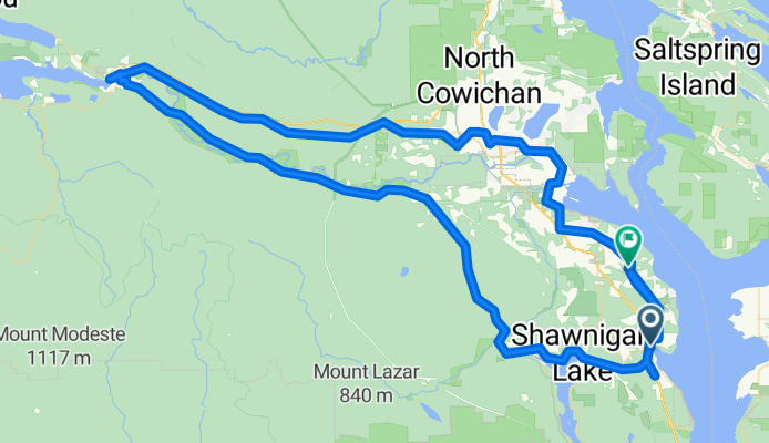
mill bay to cowichan lake
A cycling route starting in North Saanich, British Columbia, Canada.
Overview
About this route
Mill Bay Rd to Noowick (left) to Liggett (right) to Frayne (l) cross hwy to Lodgepole Rd. (r), to Deloume Rd. (r) cross hwy and parallel other side past Shawn-Mill Bay Rd onto Church Way to Kilmalu Rd (r) to Telegraph Rd.(l), past Cheeke and Wilder and Cherry Pt. and Cow. Bay Rd. to Koksilah Rd (r) then left, right, right, onto Cow Bay Rd. (watch for 1681 Cow. Bay Rd.)...to Jack Rd. (l) to Hillbank Rd. (r), back to Cow Bay Rd. (l), over river to Tzouhalem Rd. (r), to Quamichan Rd. East (l) and right onto Qwi'lus Lane and r back to Tzouhalem (l), to Valleyview Rd. (r), Sandra (l), Deborah (r), Frances (l) to Maple Bay Rd. (l), take right before roundabout, bringing you back to Tzouhalem, turn r on Jayne's Rd., to Lakes Rd. (l) to Beverly St. (r), onto Friendship Trail hairpin along TCH and back to Beverley (other side) onto Friendship Trail to roundabout Sherman Rd. (l), onto Transcanada Trail past Truesdale, which becomes Cowichan Valley Trail to Lk. Cow.
- -:--
- Duration
- 116.3 km
- Distance
- 586 m
- Ascent
- 564 m
- Descent
- ---
- Avg. speed
- ---
- Avg. speed
Route quality
Waytypes & surfaces along the route
Waytypes
Path
58.7 km
(51 %)
Road
30.7 km
(26 %)
Surfaces
Paved
45.7 km
(39 %)
Unpaved
59.1 km
(51 %)
Gravel
59 km
(51 %)
Asphalt
35 km
(30 %)
Continue with Bikemap
Use, edit, or download this cycling route
You would like to ride mill bay to cowichan lake or customize it for your own trip? Here is what you can do with this Bikemap route:
Free features
- Save this route as favorite or in collections
- Copy & plan your own version of this route
- Split it into stages to create a multi-day tour
- Sync your route with Garmin or Wahoo
Premium features
Free trial for 3 days, or one-time payment. More about Bikemap Premium.
- Navigate this route on iOS & Android
- Export a GPX / KML file of this route
- Create your custom printout (try it for free)
- Download this route for offline navigation
Discover more Premium features.
Get Bikemap PremiumFrom our community
Other popular routes starting in North Saanich
 Ferry to Victoria
- Distance
- 33.4 km
- Ascent
- 122 m
- Descent
- 122 m
- Location
- North Saanich, British Columbia, Canada
 Mary Winspear Parking Lot to Ferry Terminal
- Distance
- 5.6 km
- Ascent
- 53 m
- Descent
- 36 m
- Location
- North Saanich, British Columbia, Canada
 Swartz Bay Cowichan Lake Loop
- Distance
- 296.4 km
- Ascent
- 1,218 m
- Descent
- 1,210 m
- Location
- North Saanich, British Columbia, Canada
 Mill Bay - Cobble Hill Loop
- Distance
- 26 km
- Ascent
- 273 m
- Descent
- 273 m
- Location
- North Saanich, British Columbia, Canada
 Patricia Bay Highway 11300, Sidney to British Columbia 1 3140, Victoria
- Distance
- 39.5 km
- Ascent
- 330 m
- Descent
- 318 m
- Location
- North Saanich, British Columbia, Canada
 Full Quad Trail Loop
- Distance
- 28.7 km
- Ascent
- 607 m
- Descent
- 600 m
- Location
- North Saanich, British Columbia, Canada
 Day 3 of Summer 2008 Tour (Sidney, BC to Ladysmith via Mill Bay)
- Distance
- 95 km
- Ascent
- 610 m
- Descent
- 571 m
- Location
- North Saanich, British Columbia, Canada
 Brentwood to Sidney
- Distance
- 32.4 km
- Ascent
- 157 m
- Descent
- 157 m
- Location
- North Saanich, British Columbia, Canada
Open it in the app