

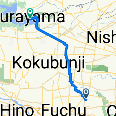
交通公園→綾南公園(Gar)
A cycling route starting in Kokubunji, Tokyo, Japan.
Overview
About this route
- -:--
- Duration
- 21 km
- Distance
- 196 m
- Ascent
- 88 m
- Descent
- ---
- Avg. speed
- ---
- Max. altitude
Route quality
Waytypes & surfaces along the route
Waytypes
Cycleway
16 km
(76 %)
Quiet road
2.7 km
(13 %)
Surfaces
Paved
16 km
(76 %)
Unpaved
0.4 km
(2 %)
Asphalt
12.2 km
(58 %)
Paved (undefined)
3.8 km
(18 %)
Route highlights
Points of interest along the route
Accommodation after 1 km
001
Point of interest after 2.5 km
アリーシャカフェ
Continue with Bikemap
Use, edit, or download this cycling route
You would like to ride 交通公園→綾南公園(Gar) or customize it for your own trip? Here is what you can do with this Bikemap route:
Free features
- Save this route as favorite or in collections
- Copy & plan your own version of this route
- Sync your route with Garmin or Wahoo
Premium features
Free trial for 3 days, or one-time payment. More about Bikemap Premium.
- Navigate this route on iOS & Android
- Export a GPX / KML file of this route
- Create your custom printout (try it for free)
- Download this route for offline navigation
Discover more Premium features.
Get Bikemap PremiumFrom our community
Other popular routes starting in Kokubunji
 29, Higashi 2-Chōme, Kunitachi to Setagaya-dori Avenue, Komae
- Distance
- 18.4 km
- Ascent
- 124 m
- Descent
- 168 m
- Location
- Kokubunji, Tokyo, Japan
 fjdjjs
- Distance
- 5.5 km
- Ascent
- 74 m
- Descent
- 69 m
- Location
- Kokubunji, Tokyo, Japan
 多摩湖サイクリング
- Distance
- 13.9 km
- Ascent
- 161 m
- Descent
- 108 m
- Location
- Kokubunji, Tokyo, Japan
 交通公園→綾南公園(Gar)
- Distance
- 21 km
- Ascent
- 196 m
- Descent
- 88 m
- Location
- Kokubunji, Tokyo, Japan
 Takao Loop Line
- Distance
- 72.7 km
- Ascent
- 455 m
- Descent
- 452 m
- Location
- Kokubunji, Tokyo, Japan
 1-19, Maeharacho 4-Chōme, Koganei to Tamako Cycling Pedestrian Road, Higashiyamato
- Distance
- 14.3 km
- Ascent
- 86 m
- Descent
- 24 m
- Location
- Kokubunji, Tokyo, Japan
 Moderate route in Machida-Shi
- Distance
- 20.8 km
- Ascent
- 279 m
- Descent
- 243 m
- Location
- Kokubunji, Tokyo, Japan
 20190211_江の島ride
- Distance
- 65.2 km
- Ascent
- 163 m
- Descent
- 199 m
- Location
- Kokubunji, Tokyo, Japan
Open it in the app