

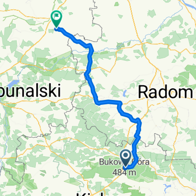
Mogiła Wasilewskiego
A cycling route starting in Suchedniów, Świętokrzyskie Voivodship, Poland.
Overview
About this route
- -:--
- Duration
- 9.6 km
- Distance
- 159 m
- Ascent
- 100 m
- Descent
- ---
- Avg. speed
- ---
- Max. altitude

Route quality
Waytypes & surfaces along the route
Waytypes
Track
7.3 km
(76 %)
Path
1.4 km
(15 %)
Surfaces
Paved
3.6 km
(37 %)
Unpaved
3.1 km
(32 %)
Asphalt
3.6 km
(37 %)
Gravel
2.7 km
(28 %)
Route highlights
Points of interest along the route
Point of interest after 6 km
Mogiła "Oseta" Władysława Wasilewskiego

Point of interest after 9.6 km
Miejsce rozwiązania I batalionu 2 Pułku Piechoty Legionów AK "Nurta"
Continue with Bikemap
Use, edit, or download this cycling route
You would like to ride Mogiła Wasilewskiego or customize it for your own trip? Here is what you can do with this Bikemap route:
Free features
- Save this route as favorite or in collections
- Copy & plan your own version of this route
- Sync your route with Garmin or Wahoo
Premium features
Free trial for 3 days, or one-time payment. More about Bikemap Premium.
- Navigate this route on iOS & Android
- Export a GPX / KML file of this route
- Create your custom printout (try it for free)
- Download this route for offline navigation
Discover more Premium features.
Get Bikemap PremiumFrom our community
Other popular routes starting in Suchedniów
 Skarżysko kamienna ale nie zapisałem 78km łącznie
- Distance
- 26.8 km
- Ascent
- 645 m
- Descent
- 592 m
- Location
- Suchedniów, Świętokrzyskie Voivodship, Poland
 KGP Cała Trasa
- Distance
- 1,680.7 km
- Ascent
- 3,601 m
- Descent
- 3,541 m
- Location
- Suchedniów, Świętokrzyskie Voivodship, Poland
 Suchedniów-Łysogóry
- Distance
- 97.5 km
- Ascent
- 914 m
- Descent
- 913 m
- Location
- Suchedniów, Świętokrzyskie Voivodship, Poland
 Mogiła Wasilewskiego
- Distance
- 9.6 km
- Ascent
- 159 m
- Descent
- 100 m
- Location
- Suchedniów, Świętokrzyskie Voivodship, Poland
 SC Do Sołtysa 80km
- Distance
- 80.4 km
- Ascent
- 589 m
- Descent
- 586 m
- Location
- Suchedniów, Świętokrzyskie Voivodship, Poland
 Ogrodowa 140, Suchedniów do Ogrodowa 140, Suchedniów
- Distance
- 86 km
- Ascent
- 673 m
- Descent
- 673 m
- Location
- Suchedniów, Świętokrzyskie Voivodship, Poland
 Wyjazd nad morze - etap 4
- Distance
- 123.7 km
- Ascent
- 218 m
- Descent
- 321 m
- Location
- Suchedniów, Świętokrzyskie Voivodship, Poland
 Trasa 2014.05.25
- Distance
- 27.7 km
- Ascent
- 395 m
- Descent
- 258 m
- Location
- Suchedniów, Świętokrzyskie Voivodship, Poland
Open it in the app