

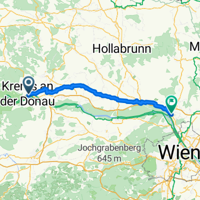
Donauradweg Etappe 6 Nordufer: Krems - Tulln
A cycling route starting in Krems, Lower Austria, Austria.
Overview
About this route
/ ACHTUNG: / Im Stadtgebiet von Krems , Höhe Ringstraße, kommt es ab Februar 2020 - Ende 2021 aufgrund einer notwendigen Leitungssanierung zu einer Umleitung des Donauradweges. Weiters wird der Treppelweg entlang der Donau bis Ende Juni saniert. Bitte der Umleitungsbeschilderung im Stadtgebiet von Krems folgen. / Auf Grund einer Baustelle ist von April 2020 bis Dezember 2021 der gesamte Abschnitt zwischen Krems und Tulln am Nordufer gesperrt. Wir bitten daher alle RadfahrerInnen, die von Krems nach Tulln oder umgekehrt unterwegs sind, den Radweg am südlichen Ufer zu verwenden. Die Umleitung ist vor Ort ausgeschildert. / Von der Mittelalter- zur Kunst- und Gartenstadt / Die heutige Tour führt Sie entlang des Nord- & Südufers der Donau aus der Kulturlandschaft Wachau heraus. Dabei starten Sie in Krems an der Donau, einer schönen Handels- und Kulturstadt und radeln auf dem Donauradweg nach Tulln an der Donau, welche auch als Kunst- und Gartenstadt bezeichnet wird. Auf dem Weg dorthin passieren Sie unter anderem Altenwörth und Zwentendorf an der Donau, bis Sie schließlich an Ihr Ziel am Südufer gelangen.
- 2 h 33 min
- Duration
- 41.4 km
- Distance
- 42 m
- Ascent
- 60 m
- Descent
- 16.2 km/h
- Avg. speed
- ---
- Max. altitude

Route quality
Waytypes & surfaces along the route
Waytypes
Track
26.3 km
(64 %)
Quiet road
6 km
(14 %)
Surfaces
Paved
41 km
(99 %)
Unpaved
0.4 km
(1 %)
Asphalt
39.9 km
(97 %)
Paved (undefined)
1 km
(2 %)
Continue with Bikemap
Use, edit, or download this cycling route
You would like to ride Donauradweg Etappe 6 Nordufer: Krems - Tulln or customize it for your own trip? Here is what you can do with this Bikemap route:
Free features
- Save this route as favorite or in collections
- Copy & plan your own version of this route
- Sync your route with Garmin or Wahoo
Premium features
Free trial for 3 days, or one-time payment. More about Bikemap Premium.
- Navigate this route on iOS & Android
- Export a GPX / KML file of this route
- Create your custom printout (try it for free)
- Download this route for offline navigation
Discover more Premium features.
Get Bikemap PremiumFrom our community
Other popular routes starting in Krems
 Unbenannte Route
- Distance
- 71.1 km
- Ascent
- 179 m
- Descent
- 206 m
- Location
- Krems, Lower Austria, Austria
 Krems-Fuglau
- Distance
- 87.3 km
- Ascent
- 961 m
- Descent
- 961 m
- Location
- Krems, Lower Austria, Austria
 Retzer Straße to Hauptplatz
- Distance
- 42.1 km
- Ascent
- 91 m
- Descent
- 111 m
- Location
- Krems, Lower Austria, Austria
 Krems-Altenwörth-Krems
- Distance
- 43.2 km
- Ascent
- 51 m
- Descent
- 50 m
- Location
- Krems, Lower Austria, Austria
 Austria-Krems am der Donau (31.05.2021, 12:34:15)
- Distance
- 78.4 km
- Ascent
- 765 m
- Descent
- 774 m
- Location
- Krems, Lower Austria, Austria
 Krems to Spitz in Wachau
- Distance
- 20.9 km
- Ascent
- 249 m
- Descent
- 218 m
- Location
- Krems, Lower Austria, Austria
 Krems - Wien 5. | Donauradweg
- Distance
- 90.1 km
- Ascent
- 240 m
- Descent
- 293 m
- Location
- Krems, Lower Austria, Austria
 Wachau túra harmadik nap
- Distance
- 42.1 km
- Ascent
- 91 m
- Descent
- 111 m
- Location
- Krems, Lower Austria, Austria
Open it in the app