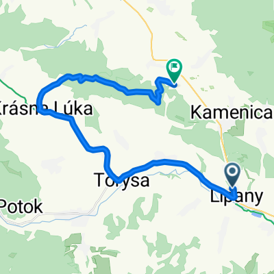
Brezovička do Brezovička
- 103.4 km
- 1,474 m
- 1,471 m
- Lipany, Prešov Region, Slovakia
A cycling route starting in Lipany, Prešov Region, Slovakia.
Overview
Difficult, demanding MTB route, challenging profile, long climbs, great views, nice ridges, singletracks, ideally split over two days: Day 1 Lipany-Sabinov, Day 2 Sabinov-Lipany.
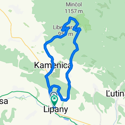
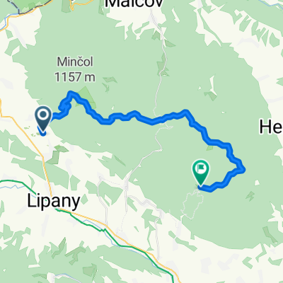
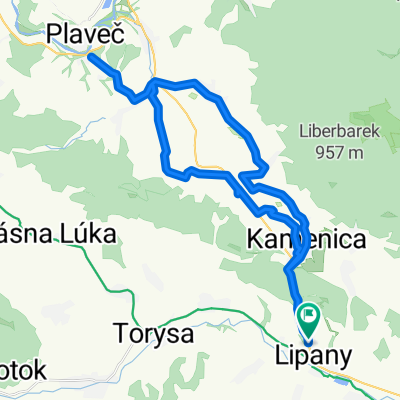
The route starts in Lipany, a small town in the Hornotorysko region. We pass over a bridge across the Toprysu river, past the sports complex towards Dubovica, at the beginning of the village turn right to the airfield – asphalt – on the hill to the left onto a dirt road, always uphill along the ridge – on a great ridge through Bandovce, on a forest road through woods and meadows up to the connection with the green trail, follow the sign to above Lacnov, from Lacnov across meadows on the red trail to the Slavkov summit, at the end of the village, then around a quarry through the valley, later right uphill on a logging road to a large rest area where we join the yellow trail leading to the summit of Smrekovica. The summit section is not rideable by bike. From the summit of Smrekovica nice views, descent on the yellow trail - trial - to Kravcova where we join the green trail. We pass through two meadows, at the third you must leave the trail onto a gravel road, about 100m right under the marker, on this road a nice descent down to Kopytovska valley – note in the valley do not go right downhill but continue the gravel road uphill, after a few hairpins we come out to the Lacnov meadows we passed before. Turn right towards Lacnov, above the village sharp left uphill to the Magura saddle, continue along the Bachuren route in the opposite direction on the green trail (Marduna peak without signage), a nice singletrack practically to Sabinov. From there asphalt road towards Drienica uphill to Lysa, from the top of Lysa continue on the green trail to the Cergov hut – a trail junction. From the hut red trail in a long climb to Cergov and Chochulka, then blue trail along the Cergov ridge to Mincol, down on the blue trail, under Zist saddle leave the trail at the end of a meadow left along a logging road to Sokola valley, under Sokola rock descend to Kamenica, in the center of the village left on the yellow trail, later left on the road to Kameniky castle, nice views, from the castle descend over a meadow to the children's camp, on asphalt right downhill to Lucka village, before the village right through a ford on a broken dirt road to the saddle below the castle, from there on the right edge of a meadow (fields) above gardens and houses into Sparova valley, by the XC route to the motor inn, then asphalt left to Lipany.
Route highlights
letisko,odbocka vlavo na polnu cestu
zadne bandovce,nivel.bod,panorama view
napojenie na tur.znacenie
bachuren-1080mnm,moznost ist cez vrchol
magura-sedlo,moznost ist rovno dole do lacnova-strmy dh,alebo po trase lucnym hrebenom do sedla a pak sotolinou do lacnova
lyziarsky areal buce-vrchna stanica
lacnov-naber vodu
sotolinovy dh,alpe style
kamenolom
odpocivadlo-lavicky,napojenie na zltu tz
skladka dreva,odbocit vlavo do lesa po zltej tz
smrekovica 1200mnm posledenych 150m s bikom na pleci,cez smrekovy les,kamenne pole,a uzkym chodnickom po hrebeni az na vrchol..panoramic view, stoji to za to
zostop zo smrekovice,hc trial,bike zniest radsej,voda,kravcova-chata,napojenie na tz,
odbocka z tz vpravo na sotolinovu cestu,tzv.kopytovska
pozor! odbocit vlavo do kopca
uphill magura-vyprostovak
javor,po zelenej tz,pekny singel track
lyz.areal zliabky,horna stanica
sedlo pod mardunou,20m severne po ceste,je na lavo studnicka
marduna-asi 500m pred vrcholom znacka odbocuje vpravo,odporucam nevsimat si ju,ist stale hore na vrchol,oplati sa,vyhlad,z mardune az do sabinova najkrajsi singletrack++
velka luka,chata
kohut-chaty-voda
sanec-dole do mesta,doplnit zasoby,pivo,pripadne prespat, a pak asfaltom cez drienicu az na lysu
lyziarsky areal drienica
hotel lysanka,hotel sport-moznost obcerstvenia
lysa 1068mnm,stoziar, panoramic view
sedlo,po znacke vpravo na chatu cergov,voda
chata cergov
paradny hreben,super vyhlady
sedlo priehyby,kriz.s asfaltkou
voda!! asi 300-500m za sedlom na pravej strane pod cestou slaby pramen,v blizkosti trasy jediny na cergove
sedlo zdiare-forgacka
predvrchol mincola,kriz,juznym smerom po chodnicku asi 500m je chata kst,moznost nabrat vodu
mincol 1157mnm-vrchol.pylon+kniha,panoramic view
v sedle odbocit prudko vlavo,cez les po modrej tz.,na luku,na konci luky zist zo znacky,cesta vlavo!!
pod sokolom,napojenie na asfaltku
sokolia skala
odbocka z asfalt. na makadam do kamenice
v kamenici pred kostolom vlavo,na kamenicky hrad-ti co maju dost rovnop asfaltom do lipan
kamenica castle
odbocka z asfaltky vpravo cez brod,hore po rozbitej makadamke,v sedle okrajom luky vlavo ponad zahrady az do sparovej
sparova,motorest,ubytovanie,pivo,crosscountry trat,odtial asfaltom do lipan -the end
Continue with Bikemap
You would like to ride lipianska trapenica or customize it for your own trip? Here is what you can do with this Bikemap route:
Free trial for 3 days, or one-time payment. More about Bikemap Premium.
Discover more Premium features.
Get Bikemap PremiumFrom our community
Open it in the app