

Burg Eltz
A cycling route starting in Moselkern, Rhineland-Palatinate, Germany.
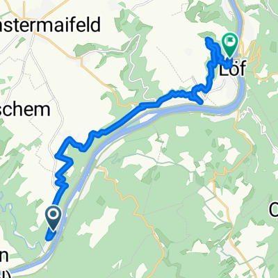
Overview
About this route
For an unknown reason, the path around the castle seems to be closed
- -:--
- Duration
- 6.7 km
- Distance
- 195 m
- Ascent
- 149 m
- Descent
- ---
- Avg. speed
- ---
- Max. altitude

Route highlights
Points of interest along the route

Point of interest after 6.2 km
Burg Eltz
Continue with Bikemap
Use, edit, or download this cycling route
You would like to ride Burg Eltz or customize it for your own trip? Here is what you can do with this Bikemap route:
Free features
- Save this route as favorite or in collections
- Copy & plan your own version of this route
- Sync your route with Garmin or Wahoo
Premium features
Free trial for 3 days, or one-time payment. More about Bikemap Premium.
- Navigate this route on iOS & Android
- Export a GPX / KML file of this route
- Create your custom printout (try it for free)
- Download this route for offline navigation
Discover more Premium features.
Get Bikemap PremiumFrom our community
Other popular routes starting in Moselkern
 Recovered Route
- Distance
- 35.5 km
- Ascent
- 74 m
- Descent
- 106 m
- Location
- Moselkern, Rhineland-Palatinate, Germany
 Moselkerner Weg 2, Müden (Mosel) nach Hatzenport
- Distance
- 7.3 km
- Ascent
- 4 m
- Descent
- 52 m
- Location
- Moselkern, Rhineland-Palatinate, Germany
 B416, Müden (Mosel) nach Moselkerner Weg 2, Müden (Mosel)
- Distance
- 0.4 km
- Ascent
- 0 m
- Descent
- 0 m
- Location
- Moselkern, Rhineland-Palatinate, Germany
 Müden, Sehnheim, Müden
- Distance
- 67.4 km
- Ascent
- 1,732 m
- Descent
- 1,747 m
- Location
- Moselkern, Rhineland-Palatinate, Germany
 21-moselkern-loef
- Distance
- 13.8 km
- Ascent
- 390 m
- Descent
- 396 m
- Location
- Moselkern, Rhineland-Palatinate, Germany
 Weinbergstraße, Moselkern nach Hauptstraße 31, Treis-Karden
- Distance
- 7.4 km
- Ascent
- 57 m
- Descent
- 71 m
- Location
- Moselkern, Rhineland-Palatinate, Germany
 6.nap Mosel
- Distance
- 104 km
- Ascent
- 102 m
- Descent
- 101 m
- Location
- Moselkern, Rhineland-Palatinate, Germany
 Fußweg zur Burg Elz 94, Moselkern nach Klostertreppe 1, Cochem
- Distance
- 19.4 km
- Ascent
- 230 m
- Descent
- 233 m
- Location
- Moselkern, Rhineland-Palatinate, Germany
Open it in the app