

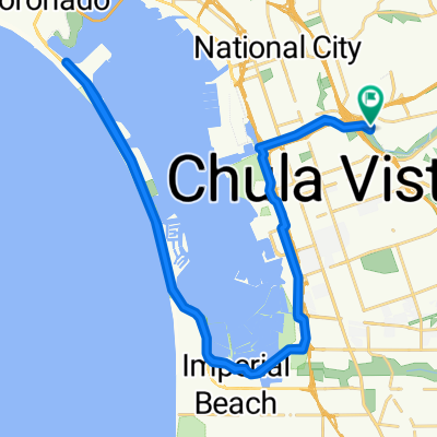
Route from 564 D St, Chula Vista
A cycling route starting in Chula Vista, California, United States.
Overview
About this route
- 28 min
- Duration
- 11.2 km
- Distance
- 3 m
- Ascent
- 19 m
- Descent
- 24.1 km/h
- Avg. speed
- ---
- Max. altitude

Route photos


Route quality
Waytypes & surfaces along the route
Waytypes
Cycleway
7.3 km
(65 %)
Quiet road
2.6 km
(23 %)
Surfaces
Paved
10.3 km
(92 %)
Asphalt
10.2 km
(91 %)
Concrete
0.1 km
(1 %)
Undefined
0.9 km
(8 %)
Continue with Bikemap
Use, edit, or download this cycling route
You would like to ride Route from 564 D St, Chula Vista or customize it for your own trip? Here is what you can do with this Bikemap route:
Free features
- Save this route as favorite or in collections
- Copy & plan your own version of this route
- Sync your route with Garmin or Wahoo
Premium features
Free trial for 3 days, or one-time payment. More about Bikemap Premium.
- Navigate this route on iOS & Android
- Export a GPX / KML file of this route
- Create your custom printout (try it for free)
- Download this route for offline navigation
Discover more Premium features.
Get Bikemap PremiumFrom our community
Other popular routes starting in Chula Vista
 Route from 564 D St, Chula Vista
- Distance
- 11.2 km
- Ascent
- 3 m
- Descent
- 19 m
- Location
- Chula Vista, California, United States
 Bayshore Bikeway, Chula Vista to Bay Blvd, San Diego
- Distance
- 30 km
- Ascent
- 60 m
- Descent
- 54 m
- Location
- Chula Vista, California, United States
 3030 Plaza Bonita Rd, National City to 1825 Strand Way, Coronado
- Distance
- 25 km
- Ascent
- 82 m
- Descent
- 95 m
- Location
- Chula Vista, California, United States
 Ring Rd, National City to Ring Rd, National City
- Distance
- 50.6 km
- Ascent
- 0 m
- Descent
- 10 m
- Location
- Chula Vista, California, United States
 Plaza Bonita Road 3374, National City to Crescent Drive 667, Chula Vista
- Distance
- 27.8 km
- Ascent
- 217 m
- Descent
- 143 m
- Location
- Chula Vista, California, United States
 Recovered Route
- Distance
- 25.9 km
- Ascent
- 11 m
- Descent
- 21 m
- Location
- Chula Vista, California, United States
 From Chula Vista to San Diego
- Distance
- 26.5 km
- Ascent
- 81 m
- Descent
- 89 m
- Location
- Chula Vista, California, United States
 Slow ride in Chula Vista
- Distance
- 39.5 km
- Ascent
- 19 m
- Descent
- 26 m
- Location
- Chula Vista, California, United States
Open it in the app