

En Kayak desde el Club Náutico Ubajay a la costanera de Santo TOmé
A cycling route starting in Paraná, Entre Ríos Province, Argentina.
Overview
About this route
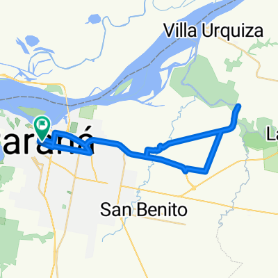
A well-paddled afternoon from Ubajay, Colastiné, access canal to the Port of Santa Fe and through the mouth of the Salado to the waterfront of Santo Tomé. In summer, bring sunscreen, a good hat, and mosquito repellent.
- -:--
- Duration
- 37.9 km
- Distance
- 34 m
- Ascent
- 33 m
- Descent
- ---
- Avg. speed
- ---
- Max. altitude

Continue with Bikemap
Use, edit, or download this cycling route
You would like to ride En Kayak desde el Club Náutico Ubajay a la costanera de Santo TOmé or customize it for your own trip? Here is what you can do with this Bikemap route:
Free features
- Save this route as favorite or in collections
- Copy & plan your own version of this route
- Sync your route with Garmin or Wahoo
Premium features
Free trial for 3 days, or one-time payment. More about Bikemap Premium.
- Navigate this route on iOS & Android
- Export a GPX / KML file of this route
- Create your custom printout (try it for free)
- Download this route for offline navigation
Discover more Premium features.
Get Bikemap PremiumFrom our community
Other popular routes starting in Paraná
 De Diamante 440, Paraná a Estación Sosa 1609, Paraná
- Distance
- 18.4 km
- Ascent
- 204 m
- Descent
- 166 m
- Location
- Paraná, Entre Ríos Province, Argentina
 Paseo rápido en Paraná
- Distance
- 10.5 km
- Ascent
- 97 m
- Descent
- 96 m
- Location
- Paraná, Entre Ríos Province, Argentina
 Interna el Morro 471, a Colón 533,
- Distance
- 15 km
- Ascent
- 127 m
- Descent
- 105 m
- Location
- Paraná, Entre Ríos Province, Argentina
 Paraná - Balsa Va Urquiza
- Distance
- 42.9 km
- Ascent
- 212 m
- Descent
- 212 m
- Location
- Paraná, Entre Ríos Province, Argentina
 aldea salto
- Distance
- 42 km
- Ascent
- 1,193 m
- Descent
- 1,198 m
- Location
- Paraná, Entre Ríos Province, Argentina
 medioruta mediobrosa
- Distance
- 24 km
- Ascent
- 103 m
- Descent
- 100 m
- Location
- Paraná, Entre Ríos Province, Argentina
 Ruta desde Montevideo 2–100, Paraná
- Distance
- 7.3 km
- Ascent
- 40 m
- Descent
- 99 m
- Location
- Paraná, Entre Ríos Province, Argentina
 Ruta desde Doctor José Urreaga 2742, Paraná
- Distance
- 5.2 km
- Ascent
- 67 m
- Descent
- 38 m
- Location
- Paraná, Entre Ríos Province, Argentina
Open it in the app