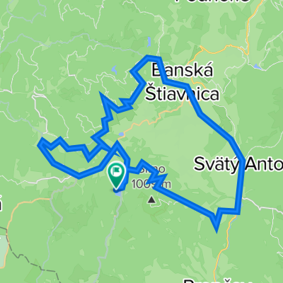
Barborská cesta - turistické trasy
6. Banská Štiavnica - Bacúrov (tursitická trasa)
A cycling route starting in Banská Štiavnica, Banská Bystrica Region, Slovakia.
Overview
About this route
From the center of Banská Štiavnica, we follow the local signs "Kalvária Banská Štiavnica" to the Calvary. When we climb towards the "upper church", it is at the very top of the Calvary. We continue down towards the "lower church", where we turn left, cross a meadow (staying rather along the lower edge of the meadow), and on the road we reach, we turn left. The small tower sign leads us through residential areas and outskirts of Banská Štiavnica, and through meadows and fields we head to Sv. Anton. We descend along the ridge past a private sawmill into the village center. Nearby is the hunting Chateau Sv. Anton. We pass through Sv. Anton and enter the forest, from where we ascend to Banský Studenec. In B. Studenec we can refresh ourselves at Kolpašské lake. We pass by the lakes, ascend through the forest, past the senior home. Along a forest road, we reach the points "Caniar" and "Volárska". The forest trail ends almost at a dilapidated complex of several buildings, where we join an asphalt road and descend into Dubové and about 2 km to Bacúrov.
- -:--
- Duration
- 27.6 km
- Distance
- 552 m
- Ascent
- 717 m
- Descent
- ---
- Avg. speed
- ---
- Max. altitude
Part of
10 stages
Route quality
Waytypes & surfaces along the route
Waytypes
Track
14.9 km
(54 %)
Quiet road
5.5 km
(20 %)
Surfaces
Paved
5.8 km
(21 %)
Unpaved
11.9 km
(43 %)
Gravel
4.7 km
(17 %)
Ground
4.7 km
(17 %)
Continue with Bikemap
Use, edit, or download this cycling route
You would like to ride 6. Banská Štiavnica - Bacúrov (tursitická trasa) or customize it for your own trip? Here is what you can do with this Bikemap route:
Free features
- Save this route as favorite or in collections
- Copy & plan your own version of this route
- Sync your route with Garmin or Wahoo
Premium features
Free trial for 3 days, or one-time payment. More about Bikemap Premium.
- Navigate this route on iOS & Android
- Export a GPX / KML file of this route
- Create your custom printout (try it for free)
- Download this route for offline navigation
Discover more Premium features.
Get Bikemap PremiumFrom our community
Other popular routes starting in Banská Štiavnica
- Č_studňa-Zlatý_Vrch-Hojan
- Distance
- 12.7 km
- Ascent
- 432 m
- Descent
- 432 m
- Location
- Banská Štiavnica, Banská Bystrica Region, Slovakia
- pukanec
- Distance
- 64 km
- Ascent
- 1,106 m
- Descent
- 1,117 m
- Location
- Banská Štiavnica, Banská Bystrica Region, Slovakia
- Okolo štiavnice
- Distance
- 51.7 km
- Ascent
- 1,355 m
- Descent
- 1,358 m
- Location
- Banská Štiavnica, Banská Bystrica Region, Slovakia
- Szczawnickie 2 - Velky Hodruzsky Okruh
- Distance
- 41.8 km
- Ascent
- 814 m
- Descent
- 813 m
- Location
- Banská Štiavnica, Banská Bystrica Region, Slovakia
- BS-HontNemce-Zemberovce-Batovce-BS
- Distance
- 81.5 km
- Ascent
- 839 m
- Descent
- 839 m
- Location
- Banská Štiavnica, Banská Bystrica Region, Slovakia
- BS-Hlink-Pukanec-Bohumnice-Pocuvadlo-BS
- Distance
- 89.3 km
- Ascent
- 1,116 m
- Descent
- 1,114 m
- Location
- Banská Štiavnica, Banská Bystrica Region, Slovakia
- Počúvadlianské jazero - Sitno - Vlčia jama - Križna - Evičkino jazero - Klinger - Banská Štiavnica
- Distance
- 16.8 km
- Ascent
- 544 m
- Descent
- 645 m
- Location
- Banská Štiavnica, Banská Bystrica Region, Slovakia
- Sitno_Pocuvadlo
- Distance
- 22.1 km
- Ascent
- 706 m
- Descent
- 708 m
- Location
- Banská Štiavnica, Banská Bystrica Region, Slovakia
Open it in the app