
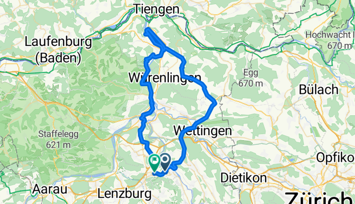
Mägenwil - Stausee Klingnau - Baden - Mägenwil
A cycling route starting in Mellingen, Canton of Aargau, Switzerland.
Overview
About this route
- 3 h 56 min
- Duration
- 65.6 km
- Distance
- 680 m
- Ascent
- 643 m
- Descent
- 16.7 km/h
- Avg. speed
- ---
- Max. altitude

Route photos

Route quality
Waytypes & surfaces along the route
Waytypes
Quiet road
20.4 km
(31 %)
Track
15.1 km
(23 %)
Surfaces
Paved
55.8 km
(85 %)
Unpaved
3.9 km
(6 %)
Asphalt
53.8 km
(82 %)
Gravel
3.3 km
(5 %)
Continue with Bikemap
Use, edit, or download this cycling route
You would like to ride Mägenwil - Stausee Klingnau - Baden - Mägenwil or customize it for your own trip? Here is what you can do with this Bikemap route:
Free features
- Save this route as favorite or in collections
- Copy & plan your own version of this route
- Sync your route with Garmin or Wahoo
Premium features
Free trial for 3 days, or one-time payment. More about Bikemap Premium.
- Navigate this route on iOS & Android
- Export a GPX / KML file of this route
- Create your custom printout (try it for free)
- Download this route for offline navigation
Discover more Premium features.
Get Bikemap PremiumFrom our community
Other popular routes starting in Mellingen
 2020-09-18
- Distance
- 29.5 km
- Ascent
- 463 m
- Descent
- 464 m
- Location
- Mellingen, Canton of Aargau, Switzerland
 Rütihof - Egelsee AG - Spreitenbach - Rütihof
- Distance
- 39.7 km
- Ascent
- 662 m
- Descent
- 662 m
- Location
- Mellingen, Canton of Aargau, Switzerland
 Mägenwil - Stausee Klingnau - Baden - Mägenwil
- Distance
- 65.6 km
- Ascent
- 680 m
- Descent
- 643 m
- Location
- Mellingen, Canton of Aargau, Switzerland
 Rütihof - Rüsler - Neuenhof - Otelfingen - Lägern entlang - Schartenfels - Wettingen - Baden - Baldegg - Rütihof
- Distance
- 38.5 km
- Ascent
- 926 m
- Descent
- 962 m
- Location
- Mellingen, Canton of Aargau, Switzerland
 Mellingen-Rüsler-Baldegg-GebiHorn-Eiteberg-Birretholz-Mellingen
- Distance
- 37.5 km
- Ascent
- 691 m
- Descent
- 693 m
- Location
- Mellingen, Canton of Aargau, Switzerland
 Rütihof - Zürich HB
- Distance
- 31.7 km
- Ascent
- 260 m
- Descent
- 261 m
- Location
- Mellingen, Canton of Aargau, Switzerland
 Im Chrumbacher 2911, Rütihof nach Im Chrumbacher 16, Rütihof
- Distance
- 24.8 km
- Ascent
- 483 m
- Descent
- 481 m
- Location
- Mellingen, Canton of Aargau, Switzerland
 Rütihof nach Baden
- Distance
- 7.8 km
- Ascent
- 67 m
- Descent
- 132 m
- Location
- Mellingen, Canton of Aargau, Switzerland
Open it in the app