

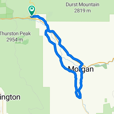
Ard Nord to Maples Camp ground
A cycling route starting in Mountain Green, Utah, United States.
Overview
About this route
- -:--
- Duration
- 5.7 km
- Distance
- 312 m
- Ascent
- 70 m
- Descent
- ---
- Avg. speed
- ---
- Max. altitude

Route highlights
Points of interest along the route
Point of interest after 2.4 km
Middle Fork trail
Continue with Bikemap
Use, edit, or download this cycling route
You would like to ride Ard Nord to Maples Camp ground or customize it for your own trip? Here is what you can do with this Bikemap route:
Free features
- Save this route as favorite or in collections
- Copy & plan your own version of this route
- Sync your route with Garmin or Wahoo
Premium features
Free trial for 3 days, or one-time payment. More about Bikemap Premium.
- Navigate this route on iOS & Android
- Export a GPX / KML file of this route
- Create your custom printout (try it for free)
- Download this route for offline navigation
Discover more Premium features.
Get Bikemap PremiumFrom our community
Other popular routes starting in Mountain Green
 Pineview Challenge
- Distance
- 141.9 km
- Ascent
- 1,762 m
- Descent
- 1,774 m
- Location
- Mountain Green, Utah, United States
 Ard Nord to Maples Camp ground
- Distance
- 5.7 km
- Ascent
- 312 m
- Descent
- 70 m
- Location
- Mountain Green, Utah, United States
 Middle fork and East fork Wheeler creek loop
- Distance
- 9.8 km
- Ascent
- 283 m
- Descent
- 283 m
- Location
- Mountain Green, Utah, United States
 Mountain Green to Franklin
- Distance
- 174.4 km
- Ascent
- 1,264 m
- Descent
- 1,469 m
- Location
- Mountain Green, Utah, United States
 Mountain Green Cycling
- Distance
- 22.6 km
- Ascent
- 204 m
- Descent
- 198 m
- Location
- Mountain Green, Utah, United States
 Wheeler to Maple at Snow Basin
- Distance
- 13.3 km
- Ascent
- 355 m
- Descent
- 355 m
- Location
- Mountain Green, Utah, United States
 SWCC ToU '16 Day 1
- Distance
- 45.4 km
- Ascent
- 998 m
- Descent
- 996 m
- Location
- Mountain Green, Utah, United States
 W Old Highway Rd, Morgan to W Old Highway Rd, Morgan
- Distance
- 49.9 km
- Ascent
- 319 m
- Descent
- 318 m
- Location
- Mountain Green, Utah, United States
Open it in the app