

"Filetowy szlak" Po puszczy zielonce
A cycling route starting in Poznan, Greater Poland Voivodeship, Poland.
Overview
About this route
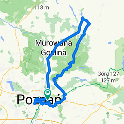
Purple trail - it's just a name that comes from the fact that I marked it on GPS in purple :DThe first section of the route is Poznań-Dziewicza Góra, ascending the mountain via the yellow trail, there were a lot of puddles in the forest, the wet sand was quite passable, but the slippery roots were dangerous.Then to Tuczna through Mielno, an interesting stretch with varied forest terrain.From Tuczna through Stęszewko and Zielonka to Okońca by Lake Miejskie. Forest around, puddles, gravel, sandy surface although initially on asphalt.To Murowana Goślina via Rakownia, there’s forest, meadows, a bit of asphalt and gravel, with sand in places.From Murowana Goślina towards Poznań trying to avoid route no. 196.The trail is demanding in places, but overall quite light, my friend rode a trekking bike and managed well, I had no problems on my MTB.
- -:--
- Duration
- 68.2 km
- Distance
- 216 m
- Ascent
- 218 m
- Descent
- ---
- Avg. speed
- ---
- Max. altitude
Route quality
Waytypes & surfaces along the route
Waytypes
Quiet road
20.4 km
(30 %)
Track
19.1 km
(28 %)
Surfaces
Paved
21.1 km
(31 %)
Unpaved
19.8 km
(29 %)
Asphalt
19.8 km
(29 %)
Ground
10.2 km
(15 %)
Continue with Bikemap
Use, edit, or download this cycling route
You would like to ride "Filetowy szlak" Po puszczy zielonce or customize it for your own trip? Here is what you can do with this Bikemap route:
Free features
- Save this route as favorite or in collections
- Copy & plan your own version of this route
- Sync your route with Garmin or Wahoo
Premium features
Free trial for 3 days, or one-time payment. More about Bikemap Premium.
- Navigate this route on iOS & Android
- Export a GPX / KML file of this route
- Create your custom printout (try it for free)
- Download this route for offline navigation
Discover more Premium features.
Get Bikemap PremiumFrom our community
Other popular routes starting in Poznan
 63.2 km route
- Distance
- 64.3 km
- Ascent
- 63 m
- Descent
- 66 m
- Location
- Poznan, Greater Poland Voivodeship, Poland
 104 przez Pobiedziska - nowsze
- Distance
- 105.2 km
- Ascent
- 143 m
- Descent
- 143 m
- Location
- Poznan, Greater Poland Voivodeship, Poland
 🇵🇱 Poznań - Skoki (65km)
- Distance
- 102.1 km
- Ascent
- 181 m
- Descent
- 180 m
- Location
- Poznan, Greater Poland Voivodeship, Poland
 "Filetowy szlak" Po puszczy zielonce
- Distance
- 68.2 km
- Ascent
- 216 m
- Descent
- 218 m
- Location
- Poznan, Greater Poland Voivodeship, Poland
 Borówiec
- Distance
- 47.2 km
- Ascent
- 78 m
- Descent
- 77 m
- Location
- Poznan, Greater Poland Voivodeship, Poland
 Kiekrz-Skorzewo-Fabianowo
- Distance
- 55.2 km
- Ascent
- 120 m
- Descent
- 121 m
- Location
- Poznan, Greater Poland Voivodeship, Poland
 Dookoła Kiekrza
- Distance
- 39 km
- Ascent
- 147 m
- Descent
- 148 m
- Location
- Poznan, Greater Poland Voivodeship, Poland
 piastowski szlak rowerowy
- Distance
- 105.8 km
- Ascent
- 553 m
- Descent
- 513 m
- Location
- Poznan, Greater Poland Voivodeship, Poland
Open it in the app