
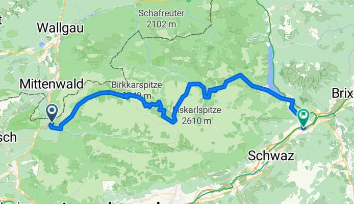
Scharnitz - Falkenhütte - Jenbach
A cycling route starting in Scharnitz, Tyrol, Austria.
Overview
About this route
Karwendeldurchquerung von Scharnitz-Bahnhof über den Hochalmsattel, kleiner Ahornboden, Laliderjoch - Plumpsjoch - Pertisau - Jenbach.
- -:--
- Duration
- 70.6 km
- Distance
- 1,906 m
- Ascent
- 2,343 m
- Descent
- ---
- Avg. speed
- ---
- Avg. speed

Route highlights
Points of interest along the route
Point of interest after 18.8 km
Karwendelhaus
Point of interest after 19.7 km
Hochalmsattel
Point of interest after 31.5 km
Falkenhütte
Point of interest after 51.7 km
Pumpsjoch
Continue with Bikemap
Use, edit, or download this cycling route
You would like to ride Scharnitz - Falkenhütte - Jenbach or customize it for your own trip? Here is what you can do with this Bikemap route:
Free features
- Save this route as favorite or in collections
- Copy & plan your own version of this route
- Sync your route with Garmin or Wahoo
Premium features
Free trial for 3 days, or one-time payment. More about Bikemap Premium.
- Navigate this route on iOS & Android
- Export a GPX / KML file of this route
- Create your custom printout (try it for free)
- Download this route for offline navigation
Discover more Premium features.
Get Bikemap PremiumFrom our community
Other popular routes starting in Scharnitz
 MiWA>Verona
- Distance
- 486.2 km
- Ascent
- 2,568 m
- Descent
- 3,507 m
- Location
- Scharnitz, Tyrol, Austria
 Karwendeltal bis Karwendelhaus
- Distance
- 35.5 km
- Ascent
- 822 m
- Descent
- 822 m
- Location
- Scharnitz, Tyrol, Austria
 Hinterriss - Falkenhütte
- Distance
- 31.7 km
- Ascent
- 971 m
- Descent
- 975 m
- Location
- Scharnitz, Tyrol, Austria
 Karwendeldurchquerung
- Distance
- 66.5 km
- Ascent
- 1,520 m
- Descent
- 1,952 m
- Location
- Scharnitz, Tyrol, Austria
 Neuried zum Karwendelhaus und zurück
- Distance
- 248.6 km
- Ascent
- 3,146 m
- Descent
- 3,146 m
- Location
- Scharnitz, Tyrol, Austria
 Karwendeltour 2009
- Distance
- 86.5 km
- Ascent
- 1,447 m
- Descent
- 1,843 m
- Location
- Scharnitz, Tyrol, Austria
 Mittelschwerer Alpencross X10 via Brenta Dolomiti Aktualisiert am 15.09.2015
- Distance
- 439.4 km
- Ascent
- 11,607 m
- Descent
- 12,532 m
- Location
- Scharnitz, Tyrol, Austria
 cbm MTB-Tour Falkenhütte
- Distance
- 25.5 km
- Ascent
- 1,367 m
- Descent
- 575 m
- Location
- Scharnitz, Tyrol, Austria
Open it in the app