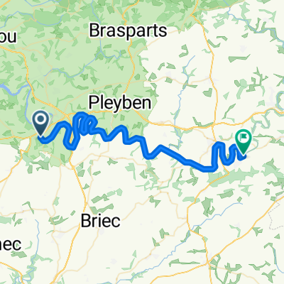
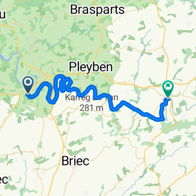
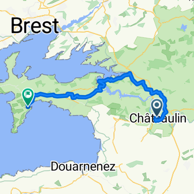
Trip vélo
A cycling route starting in Châteaulin, Brittany Region, France.
Overview
About this route
- -:--
- Duration
- 1,382.8 km
- Distance
- 3,173 m
- Ascent
- 2,479 m
- Descent
- ---
- Avg. speed
- ---
- Avg. speed
Route quality
Waytypes & surfaces along the route
Waytypes
Quiet road
498.6 km
(36 %)
Road
279 km
(20 %)
Surfaces
Paved
685 km
(50 %)
Unpaved
147.1 km
(11 %)
Asphalt
652.1 km
(47 %)
Gravel
111.3 km
(8 %)
Route highlights
Points of interest along the route
Accommodation after 171.7 km
Chantal & Paul
Point of interest after 208.8 km
L'ile aux Pies
Point of interest after 308 km
Se garer de l'autre coté du pont et traversé l'Erdre par les escaliers. Engagé, moulinette conseillée
Point of interest after 314.8 km
Vélo contact
Point of interest after 314.8 km
EL CAP
Point of interest after 314.9 km
Pic & Paroi - Le Bloc Salle d'escalade
Point of interest after 404.1 km
La Pierre Bécherelle beau monolithe naturel. Son nom viendrait de « Béchet », le brochet en vieux patois local. L’endroit était réputé pour la pêche de ce poisson. Autrefois beaucoup plus imposant, il a été utilisé plusieurs fois pour en extraire de la pierre de construction jusqu'en 1843, date à laquelle de violentes manifestations populaires opposées à cette pratique les en empêchèrent.
Point of interest after 413.5 km
La Roche de Mûrs Après avoir rejoint le restaurant à pied, prendre à gauche, longer la falaise jusqu'à la fin du champs de vigne. Prendre le petit sentier qui descend sur la droite, descendre les escaliers. Une fois arrivé dans le hameau, prendre la première à droite, arrivé en bordure de rivière, prendre à droite et marcher sur 500m.
Point of interest after 611.5 km
Falaise du Coteau (La Chaussée Saint Victor)
Point of interest after 614 km
Viaduc des Noël
Point of interest after 677.8 km
Digues de la Loire -> 6c
Continue with Bikemap
Use, edit, or download this cycling route
You would like to ride Trip vélo or customize it for your own trip? Here is what you can do with this Bikemap route:
Free features
- Save this route as favorite or in collections
- Copy & plan your own version of this route
- Sync your route with Garmin or Wahoo
Premium features
Free trial for 3 days, or one-time payment. More about Bikemap Premium.
- Navigate this route on iOS & Android
- Export a GPX / KML file of this route
- Create your custom printout (try it for free)
- Download this route for offline navigation
Discover more Premium features.
Get Bikemap PremiumFrom our community
Other popular routes starting in Châteaulin
- La Pointe (Camping) - Brest - Pointe Saint-Mathieu
- Distance
- 87.8 km
- Ascent
- 658 m
- Descent
- 669 m
- Location
- Châteaulin, Brittany Region, France
- Day 4 Friday 17 May 9663 km
- Distance
- 95.9 km
- Ascent
- 640 m
- Descent
- 669 m
- Location
- Châteaulin, Brittany Region, France
- Itinéraire modéré en Landévennec
- Distance
- 34.5 km
- Ascent
- 553 m
- Descent
- 598 m
- Location
- Châteaulin, Brittany Region, France
- Torture de France
- Distance
- 686.8 km
- Ascent
- 497 m
- Descent
- 429 m
- Location
- Châteaulin, Brittany Region, France
- Trip vélo
- Distance
- 1,382.8 km
- Ascent
- 3,173 m
- Descent
- 2,479 m
- Location
- Châteaulin, Brittany Region, France
- Circuit
- Distance
- 68.9 km
- Ascent
- 629 m
- Descent
- 628 m
- Location
- Châteaulin, Brittany Region, France
- Boucles de l'Aulne
- Distance
- 17.1 km
- Ascent
- 279 m
- Descent
- 278 m
- Location
- Châteaulin, Brittany Region, France
- Port-Launay- Chateauneuf
- Distance
- 91.6 km
- Ascent
- 1,207 m
- Descent
- 1,216 m
- Location
- Châteaulin, Brittany Region, France
Open it in the app