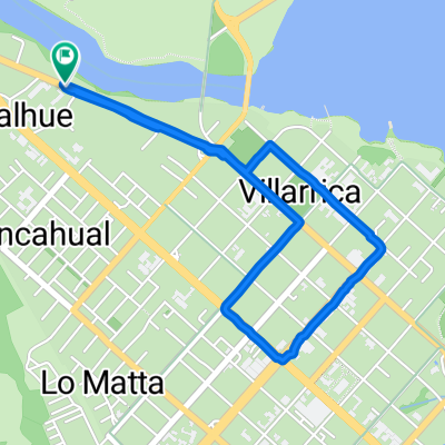
Ciclotur verano 2011
A cycling route starting in Villarrica, Región de la Araucanía, Chile.
Overview
About this route
- -:--
- Duration
- 649.6 km
- Distance
- 3,173 m
- Ascent
- 3,373 m
- Descent
- ---
- Avg. speed
- ---
- Max. altitude
Route highlights
Points of interest along the route
Point of interest after 47.5 km
cruce a palguin
Point of interest after 74.1 km
Point of interest after 80.7 km
el video de mi cleta
Point of interest after 80.8 km
Point of interest after 116.7 km
Point of interest after 147.6 km
en balsa
Point of interest after 173.8 km
balsa
Point of interest after 183.4 km
Argentina
Point of interest after 473.3 km
balsa
Continue with Bikemap
Use, edit, or download this cycling route
You would like to ride Ciclotur verano 2011 or customize it for your own trip? Here is what you can do with this Bikemap route:
Free features
- Save this route as favorite or in collections
- Copy & plan your own version of this route
- Split it into stages to create a multi-day tour
- Sync your route with Garmin or Wahoo
Premium features
Free trial for 3 days, or one-time payment. More about Bikemap Premium.
- Navigate this route on iOS & Android
- Export a GPX / KML file of this route
- Create your custom printout (try it for free)
- Download this route for offline navigation
Discover more Premium features.
Get Bikemap PremiumFrom our community
Other popular routes starting in Villarrica
- Lake District 8. Etappe Villarrica - Coñaripe
- Distance
- 52.5 km
- Ascent
- 496 m
- Descent
- 501 m
- Location
- Villarrica, Región de la Araucanía, Chile
- Villarrica - Junin de los Andes
- Distance
- 169.7 km
- Ascent
- 1,649 m
- Descent
- 1,158 m
- Location
- Villarrica, Región de la Araucanía, Chile
- Ciclotur verano 2011
- Distance
- 649.6 km
- Ascent
- 3,173 m
- Descent
- 3,373 m
- Location
- Villarrica, Región de la Araucanía, Chile
- Villarrica - Pucón #6 (7 Lagos Chile)
- Distance
- 37.6 km
- Ascent
- 550 m
- Descent
- 548 m
- Location
- Villarrica, Región de la Araucanía, Chile
- Cervecería Cráter
- Distance
- 20 km
- Ascent
- 219 m
- Descent
- 221 m
- Location
- Villarrica, Región de la Araucanía, Chile
- De Pasaje Pedregoso, Villarrica a Nuevo Porvenir, Villarrica
- Distance
- 4.6 km
- Ascent
- 72 m
- Descent
- 15 m
- Location
- Villarrica, Región de la Araucanía, Chile
- Villarica - Pucón
- Distance
- 23.3 km
- Ascent
- 216 m
- Descent
- 210 m
- Location
- Villarrica, Región de la Araucanía, Chile
- Conquil-Lefun
- Distance
- 21.7 km
- Ascent
- 185 m
- Descent
- 185 m
- Location
- Villarrica, Región de la Araucanía, Chile
Open it in the app