

Canal del Midi
A cycling route starting in Ramonville-Saint-Agne, Occitanie, France.
Overview
About this route
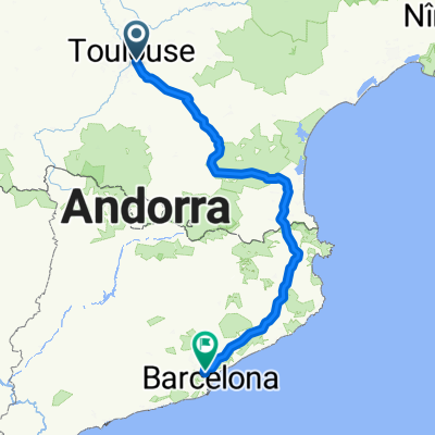
Toulouse-Montferrand-Revel-Castelnaudary
- -:--
- Duration
- 94.9 km
- Distance
- 389 m
- Ascent
- 364 m
- Descent
- ---
- Avg. speed
- ---
- Max. altitude

Route quality
Waytypes & surfaces along the route
Waytypes
Path
41.8 km
(44 %)
Quiet road
23.7 km
(25 %)
Surfaces
Paved
57.9 km
(61 %)
Unpaved
14.2 km
(15 %)
Asphalt
57.9 km
(61 %)
Gravel
6.6 km
(7 %)
Route highlights
Points of interest along the route
Point of interest after 0 km
airbnb
Accommodation after 0 km
Camping Le Moulin de Bidounet (17€) https://www.camping-moissac.com/fr
Accommodation after 0 km
Camping Montech (20€) http://www.camping-montech.fr/
Accommodation after 0 km
Camping Le Rupé (20€) camping-toulouse.com
Accommodation after 0.1 km
Camping Moulin de Mellet (17€) https://camping-moulin-mellet.com/
Point of interest after 0.1 km
Camping de la Bouriette (20€) https://www.camping-la-bouriette-toulouse.fr/plan
Accommodation after 0.1 km
CAMPING AU JARDIN (10'5€?)
Accommodation after 0.1 km
Camping Yelloh (37€, igual menos) https://www.camping-bordeaux.com/
Accommodation after 0.1 km
Camping Valence d´Agen no hay web, buenas críticas en Google
Accommodation after 0.1 km
Camping La Reole (10€) https://www.lareole.fr/vivre-la-reole/visiter-sejourner/#a-sejourner
Point of interest after 71.4 km
Mercado de Revel, los Sábados.
Point of interest after 74.4 km
camping les peupliers (25€) https://www.camping-colombiers.com/pdf/tarifs-emplacement.pdf
Point of interest after 74.4 km
Camping Balaruc Les Bains (18€) https://www.camping-maridor.com/media/fichier/tarifs2020.pdf
Point of interest after 74.4 km
Camping Le Parc (24€) https://www.campingfrance.com/es/busque-su-camping/occitania/herault/lattes/le-parc2
Point of interest after 74.4 km
Camping Gites du Soleil (20€) http://www.campinglesolivierscreissan.com/fr/village-de-gtes/
Point of interest after 74.4 km
Camping Maridor 44€ https://www.camping-maridor.com/media/fichier/tarifs2020.pdf
Point of interest after 74.9 km
Saint Ferreol, museo del canal y lago/bassin
Point of interest after 90.4 km
Camping la Cité https://campingcitecarcassonne.com/index.php/tarifs-2020/?lang=es
Point of interest after 94.8 km
Camping de la Giraille 12€ https://www.castelnaudary-tourisme.fr/es/dormir/aires-de-camping-car/247-camping-les-fontanilles-2/
Continue with Bikemap
Use, edit, or download this cycling route
You would like to ride Canal del Midi or customize it for your own trip? Here is what you can do with this Bikemap route:
Free features
- Save this route as favorite or in collections
- Copy & plan your own version of this route
- Split it into stages to create a multi-day tour
- Sync your route with Garmin or Wahoo
Premium features
Free trial for 3 days, or one-time payment. More about Bikemap Premium.
- Navigate this route on iOS & Android
- Export a GPX / KML file of this route
- Create your custom printout (try it for free)
- Download this route for offline navigation
Discover more Premium features.
Get Bikemap PremiumFrom our community
Other popular routes starting in Ramonville-Saint-Agne
 153 bis Avenue de Lespinet, Toulouse à Avenue de Lespinet, Toulouse
- Distance
- 9.1 km
- Ascent
- 61 m
- Descent
- 59 m
- Location
- Ramonville-Saint-Agne, Occitanie, France
 Canal du Midi - --Ramonville-Saint-Agne-- OR-4859040:canal du midi
- Distance
- 319.8 km
- Ascent
- 1,017 m
- Descent
- 1,171 m
- Location
- Ramonville-Saint-Agne, Occitanie, France
 Les coteaux
- Distance
- 37.3 km
- Ascent
- 317 m
- Descent
- 319 m
- Location
- Ramonville-Saint-Agne, Occitanie, France
 St Orens, Ste Foy d'Aigrefeuille, Quint
- Distance
- 31.1 km
- Ascent
- 101 m
- Descent
- 102 m
- Location
- Ramonville-Saint-Agne, Occitanie, France
 Autour de Vieille Toulouse
- Distance
- 39 km
- Ascent
- 345 m
- Descent
- 347 m
- Location
- Ramonville-Saint-Agne, Occitanie, France
 Canal del Midi
- Distance
- 94.9 km
- Ascent
- 389 m
- Descent
- 364 m
- Location
- Ramonville-Saint-Agne, Occitanie, France
 Medical Biketour 2014
- Distance
- 390.1 km
- Ascent
- 1,232 m
- Descent
- 1,083 m
- Location
- Ramonville-Saint-Agne, Occitanie, France
 Toulouse_Carcassonne
- Distance
- 99.7 km
- Ascent
- 50 m
- Descent
- 90 m
- Location
- Ramonville-Saint-Agne, Occitanie, France
Open it in the app