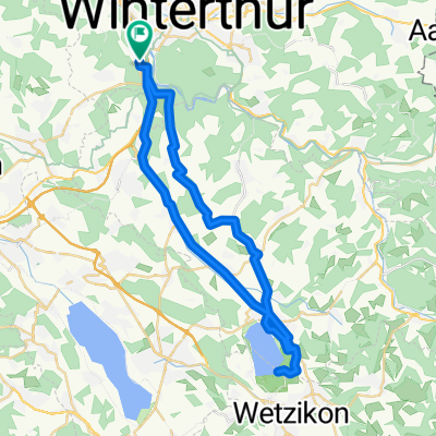
001 Dättnau - Egnach, SA 25.07.20
A cycling route starting in Töss (Kreis 4), Canton of Zurich, Switzerland.
Overview
About this route
- -:--
- Duration
- 71.4 km
- Distance
- 317 m
- Ascent
- 378 m
- Descent
- ---
- Avg. speed
- ---
- Avg. speed
Route quality
Waytypes & surfaces along the route
Waytypes
Track
28.3 km
(40 %)
Quiet road
26.4 km
(37 %)
Surfaces
Paved
41.9 km
(59 %)
Unpaved
17.4 km
(24 %)
Asphalt
36.3 km
(51 %)
Gravel
12.8 km
(18 %)
Continue with Bikemap
Use, edit, or download this cycling route
You would like to ride 001 Dättnau - Egnach, SA 25.07.20 or customize it for your own trip? Here is what you can do with this Bikemap route:
Free features
- Save this route as favorite or in collections
- Copy & plan your own version of this route
- Sync your route with Garmin or Wahoo
Premium features
Free trial for 3 days, or one-time payment. More about Bikemap Premium.
- Navigate this route on iOS & Android
- Export a GPX / KML file of this route
- Create your custom printout (try it for free)
- Download this route for offline navigation
Discover more Premium features.
Get Bikemap PremiumFrom our community
Other popular routes starting in Töss (Kreis 4)
- UHU Golfplatz-First-Wald-Töss
- Distance
- 23.8 km
- Ascent
- 341 m
- Descent
- 341 m
- Location
- Töss (Kreis 4), Canton of Zurich, Switzerland
- Töss runde
- Distance
- 19.8 km
- Ascent
- 125 m
- Descent
- 129 m
- Location
- Töss (Kreis 4), Canton of Zurich, Switzerland
- Winterthur to Freudenstadt
- Distance
- 148.8 km
- Ascent
- 1,305 m
- Descent
- 991 m
- Location
- Töss (Kreis 4), Canton of Zurich, Switzerland
- 001 Dättnau - Egnach, SA 25.07.20
- Distance
- 71.4 km
- Ascent
- 317 m
- Descent
- 378 m
- Location
- Töss (Kreis 4), Canton of Zurich, Switzerland
- Winterberg-Hulftegg-Winterberg
- Distance
- 81.4 km
- Ascent
- 823 m
- Descent
- 823 m
- Location
- Töss (Kreis 4), Canton of Zurich, Switzerland
- Arbeitsweg Jasmin hinweg
- Distance
- 10.6 km
- Ascent
- 75 m
- Descent
- 101 m
- Location
- Töss (Kreis 4), Canton of Zurich, Switzerland
- Winterthur - Schauenberg
- Distance
- 47.4 km
- Ascent
- 728 m
- Descent
- 728 m
- Location
- Töss (Kreis 4), Canton of Zurich, Switzerland
- Falch Rund um Winterthur
- Distance
- 31.9 km
- Ascent
- 192 m
- Descent
- 192 m
- Location
- Töss (Kreis 4), Canton of Zurich, Switzerland
Open it in the app