

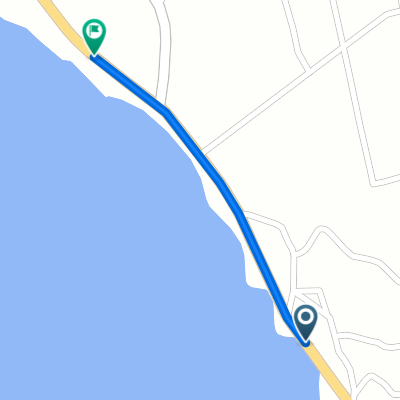
Moderate route in Chita-Shi
A cycling route starting in Tokoname, Aichi, Japan.
Overview
About this route
- 3 h 27 min
- Duration
- 21.9 km
- Distance
- 180 m
- Ascent
- 183 m
- Descent
- 6.4 km/h
- Avg. speed
- ---
- Max. altitude

Continue with Bikemap
Use, edit, or download this cycling route
You would like to ride Moderate route in Chita-Shi or customize it for your own trip? Here is what you can do with this Bikemap route:
Free features
- Save this route as favorite or in collections
- Copy & plan your own version of this route
- Sync your route with Garmin or Wahoo
Premium features
Free trial for 3 days, or one-time payment. More about Bikemap Premium.
- Navigate this route on iOS & Android
- Export a GPX / KML file of this route
- Create your custom printout (try it for free)
- Download this route for offline navigation
Discover more Premium features.
Get Bikemap PremiumFrom our community
Other popular routes starting in Tokoname
 Moderate route in Chita-Shi
- Distance
- 21.9 km
- Ascent
- 180 m
- Descent
- 183 m
- Location
- Tokoname, Aichi, Japan
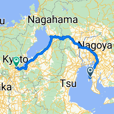
 Japan-trip
- Distance
- 2,255.8 km
- Ascent
- 6,575 m
- Descent
- 6,574 m
- Location
- Tokoname, Aichi, Japan
 ⑬萬緑 知多運動公園
- Distance
- 6.5 km
- Ascent
- 36 m
- Descent
- 36 m
- Location
- Tokoname, Aichi, Japan
 Chita 70.3 Bike course
- Distance
- 90.1 km
- Ascent
- 172 m
- Descent
- 126 m
- Location
- Tokoname, Aichi, Japan
 9−2, 常滑市 to 岐阜市
- Distance
- 70.6 km
- Ascent
- 622 m
- Descent
- 638 m
- Location
- Tokoname, Aichi, Japan
 9−2, 常滑市 to 東丸山, 東海市
- Distance
- 20.1 km
- Ascent
- 265 m
- Descent
- 282 m
- Location
- Tokoname, Aichi, Japan
 ⑨便器のベンチ
- Distance
- 0.6 km
- Ascent
- 0 m
- Descent
- 0 m
- Location
- Tokoname, Aichi, Japan
 From Nagoya to Osaka
- Distance
- 219.9 km
- Ascent
- 1,127 m
- Descent
- 1,079 m
- Location
- Tokoname, Aichi, Japan
Open it in the app