

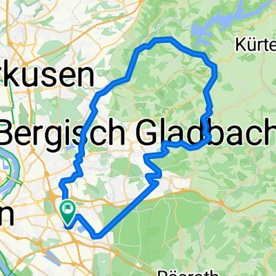
Flughafen-Wildgehege
A cycling route starting in Ostheim, North Rhine-Westphalia, Germany.
Overview
About this route
- 2 h 38 min
- Duration
- 43.6 km
- Distance
- 250 m
- Ascent
- 251 m
- Descent
- 16.6 km/h
- Avg. speed
- ---
- Max. altitude
Route quality
Waytypes & surfaces along the route
Waytypes
Path
18.7 km
(43 %)
Quiet road
11.3 km
(26 %)
Surfaces
Paved
34 km
(78 %)
Unpaved
0.9 km
(2 %)
Asphalt
30.1 km
(69 %)
Concrete
2.2 km
(5 %)
Continue with Bikemap
Use, edit, or download this cycling route
You would like to ride Flughafen-Wildgehege or customize it for your own trip? Here is what you can do with this Bikemap route:
Free features
- Save this route as favorite or in collections
- Copy & plan your own version of this route
- Sync your route with Garmin or Wahoo
Premium features
Free trial for 3 days, or one-time payment. More about Bikemap Premium.
- Navigate this route on iOS & Android
- Export a GPX / KML file of this route
- Create your custom printout (try it for free)
- Download this route for offline navigation
Discover more Premium features.
Get Bikemap PremiumFrom our community
Other popular routes starting in Ostheim
 Neschen
- Distance
- 50.9 km
- Ascent
- 385 m
- Descent
- 357 m
- Location
- Ostheim, North Rhine-Westphalia, Germany
 MTB Sprint
- Distance
- 4.5 km
- Ascent
- 16 m
- Descent
- 19 m
- Location
- Ostheim, North Rhine-Westphalia, Germany
 Ostmerheimer Straße 55B, Кельн до Fußfallstraße 62, Кельн
- Distance
- 10.7 km
- Ascent
- 26 m
- Descent
- 25 m
- Location
- Ostheim, North Rhine-Westphalia, Germany
 RR-CG-Bonn-RR
- Distance
- 65.4 km
- Ascent
- 67 m
- Descent
- 67 m
- Location
- Ostheim, North Rhine-Westphalia, Germany
 R24.08.2017 Köln
- Distance
- 32.7 km
- Ascent
- 63 m
- Descent
- 64 m
- Location
- Ostheim, North Rhine-Westphalia, Germany
 Rund um Flughafen
- Distance
- 39.7 km
- Ascent
- 145 m
- Descent
- 145 m
- Location
- Ostheim, North Rhine-Westphalia, Germany
 Untereschbach, Kürten, Dhünn, Altenburg
- Distance
- 80.9 km
- Ascent
- 872 m
- Descent
- 852 m
- Location
- Ostheim, North Rhine-Westphalia, Germany
 Köln - Oostkapelle
- Distance
- 319.1 km
- Ascent
- 185 m
- Descent
- 237 m
- Location
- Ostheim, North Rhine-Westphalia, Germany
Open it in the app