

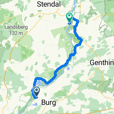
Elberadweg 11 - KEH-MB
A cycling route starting in Rogätz, Saxony-Anhalt, Germany.
Overview
About this route
Elberadweg 11
Kehnert - Magdeburg
Tag 13
- -:--
- Duration
- 44.3 km
- Distance
- 77 m
- Ascent
- 71 m
- Descent
- ---
- Avg. speed
- ---
- Max. altitude

Route quality
Waytypes & surfaces along the route
Waytypes
Track
16.4 km
(37 %)
Path
10.2 km
(23 %)
Surfaces
Paved
28.8 km
(65 %)
Unpaved
2.2 km
(5 %)
Asphalt
26.1 km
(59 %)
Concrete
2.2 km
(5 %)
Continue with Bikemap
Use, edit, or download this cycling route
You would like to ride Elberadweg 11 - KEH-MB or customize it for your own trip? Here is what you can do with this Bikemap route:
Free features
- Save this route as favorite or in collections
- Copy & plan your own version of this route
- Sync your route with Garmin or Wahoo
Premium features
Free trial for 3 days, or one-time payment. More about Bikemap Premium.
- Navigate this route on iOS & Android
- Export a GPX / KML file of this route
- Create your custom printout (try it for free)
- Download this route for offline navigation
Discover more Premium features.
Get Bikemap PremiumFrom our community
Other popular routes starting in Rogätz
 16.07.29 Blumenthal-Wulkau
- Distance
- 70.7 km
- Ascent
- 132 m
- Descent
- 142 m
- Location
- Rogätz, Saxony-Anhalt, Germany
 Alte Bergstraße nach Töpferstraße
- Distance
- 54.8 km
- Ascent
- 123 m
- Descent
- 119 m
- Location
- Rogätz, Saxony-Anhalt, Germany
 Niegripper Weg 16, Burg nach Niegripper Weg 16, Burg
- Distance
- 33 km
- Ascent
- 92 m
- Descent
- 93 m
- Location
- Rogätz, Saxony-Anhalt, Germany
 solo_2024_23_Elbe_3_Gartow
- Distance
- 113.4 km
- Ascent
- 348 m
- Descent
- 338 m
- Location
- Rogätz, Saxony-Anhalt, Germany
 Bertingen-Nauen / 6.Tag von 6 Tagen
- Distance
- 127.1 km
- Ascent
- 356 m
- Descent
- 370 m
- Location
- Rogätz, Saxony-Anhalt, Germany
 Im Wald, Angern nach Im Wald, Angern
- Distance
- 1.3 km
- Ascent
- 32 m
- Descent
- 26 m
- Location
- Rogätz, Saxony-Anhalt, Germany
 ERW8: Schartau--Parey Schleuse--Ferchland--Jericho (Kloster)--Tangermünde
- Distance
- 49.3 km
- Ascent
- 66 m
- Descent
- 63 m
- Location
- Rogätz, Saxony-Anhalt, Germany
 Tag 2 Rogätz - Wittenberge
- Distance
- 114.2 km
- Ascent
- 74 m
- Descent
- 95 m
- Location
- Rogätz, Saxony-Anhalt, Germany
Open it in the app