Overview
About this route
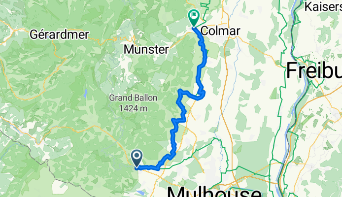
From Thann to Turckheim
- -:--
- Duration
- 58.7 km
- Distance
- 227 m
- Ascent
- 327 m
- Descent
- ---
- Avg. speed
- ---
- Max. altitude
Part of
Tour d'Alsace
4 stages
Route quality
Waytypes & surfaces along the route
Waytypes
Quiet road
21.1 km
(36 %)
Road
12.9 km
(22 %)
Surfaces
Paved
37.6 km
(64 %)
Unpaved
0.6 km
(1 %)
Asphalt
27 km
(46 %)
Paved (undefined)
10.6 km
(18 %)
Continue with Bikemap
Use, edit, or download this cycling route
You would like to ride Alsace étape1 or customize it for your own trip? Here is what you can do with this Bikemap route:
Free features
- Save this route as favorite or in collections
- Copy & plan your own version of this route
- Sync your route with Garmin or Wahoo
Premium features
Free trial for 3 days, or one-time payment. More about Bikemap Premium.
- Navigate this route on iOS & Android
- Export a GPX / KML file of this route
- Create your custom printout (try it for free)
- Download this route for offline navigation
Discover more Premium features.
Get Bikemap PremiumFrom our community
Other popular routes starting in Vieux-Thann
- Thann - Urbes
- Distance
- 44 km
- Ascent
- 630 m
- Descent
- 629 m
- Location
- Vieux-Thann, Grand Est, France
- V19-2a Ballon-Servance-La Planche
- Distance
- 139.1 km
- Ascent
- 2,327 m
- Descent
- 2,333 m
- Location
- Vieux-Thann, Grand Est, France
- ABC23 Stage 5a faulty - Thann to Colmar via Route des Cretes
- Distance
- 101.9 km
- Ascent
- 1,996 m
- Descent
- 2,140 m
- Location
- Vieux-Thann, Grand Est, France
- 1999-08-13 CTAV Vosges J05
- Distance
- 33.2 km
- Ascent
- 1,068 m
- Descent
- 931 m
- Location
- Vieux-Thann, Grand Est, France
- Long ride from Vieux-Thann to Belfort
- Distance
- 120.2 km
- Ascent
- 1,496 m
- Descent
- 1,472 m
- Location
- Vieux-Thann, Grand Est, France
- La Vosgienne, 160 km, 3.300 HM
- Distance
- 153.2 km
- Ascent
- 2,957 m
- Descent
- 2,958 m
- Location
- Vieux-Thann, Grand Est, France
- 22/07/2020 07:53:22
- Distance
- 84.6 km
- Ascent
- 316 m
- Descent
- 316 m
- Location
- Vieux-Thann, Grand Est, France
- Thann-Col du Hundsruck-Thann
- Distance
- 39.5 km
- Ascent
- 663 m
- Descent
- 663 m
- Location
- Vieux-Thann, Grand Est, France
Open it in the app