

Overview
About this route
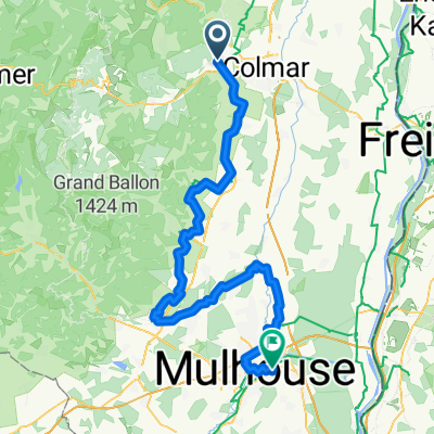
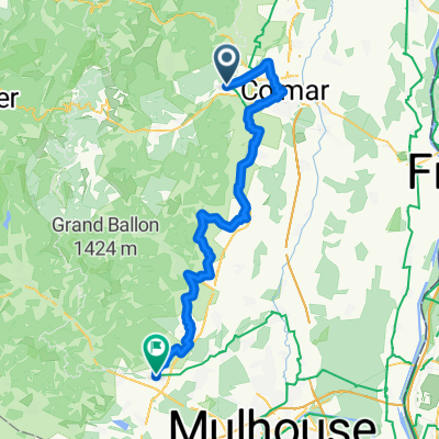
Turckheim - Molsheim
- -:--
- Duration
- 73.9 km
- Distance
- 274 m
- Ascent
- 332 m
- Descent
- ---
- Avg. speed
- ---
- Max. altitude

Part of
Tour d'Alsace
4 stages
Route quality
Waytypes & surfaces along the route
Waytypes
Quiet road
27.4 km
(37 %)
Track
20 km
(27 %)
Surfaces
Paved
51.8 km
(70 %)
Asphalt
38.4 km
(52 %)
Paved (undefined)
11.8 km
(16 %)
Continue with Bikemap
Use, edit, or download this cycling route
You would like to ride Alsace Etappe 2 or customize it for your own trip? Here is what you can do with this Bikemap route:
Free features
- Save this route as favorite or in collections
- Copy & plan your own version of this route
- Sync your route with Garmin or Wahoo
Premium features
Free trial for 3 days, or one-time payment. More about Bikemap Premium.
- Navigate this route on iOS & Android
- Export a GPX / KML file of this route
- Create your custom printout (try it for free)
- Download this route for offline navigation
Discover more Premium features.
Get Bikemap PremiumFrom our community
Other popular routes starting in Turckheim
 RT40km Türkheim - Kientzheim - Ribeauville - Bennwir - Türkheim
- Distance
- 38.4 km
- Ascent
- 410 m
- Descent
- 412 m
- Location
- Turckheim, Grand Est, France
 Von Türkheim bis Riedisheim
- Distance
- 89.3 km
- Ascent
- 392 m
- Descent
- 385 m
- Location
- Turckheim, Grand Est, France
 From Turckheim to Oberhausbergen
- Distance
- 85.9 km
- Ascent
- 69 m
- Descent
- 165 m
- Location
- Turckheim, Grand Est, France
 3chtx-first-3épis
- Distance
- 55 km
- Ascent
- 1,308 m
- Descent
- 1,302 m
- Location
- Turckheim, Grand Est, France
 2022.4 (1) : Niedermorschwihl - Platzerwasel
- Distance
- 33.1 km
- Ascent
- 1,114 m
- Descent
- 182 m
- Location
- Turckheim, Grand Est, France
 Col de la Schlucht über Münstertal
- Distance
- 73.4 km
- Ascent
- 1,338 m
- Descent
- 1,338 m
- Location
- Turckheim, Grand Est, France
 J3 Turckheim to Cernay
- Distance
- 63.6 km
- Ascent
- 356 m
- Descent
- 295 m
- Location
- Turckheim, Grand Est, France
 Alsace Etappe 2
- Distance
- 73.9 km
- Ascent
- 274 m
- Descent
- 332 m
- Location
- Turckheim, Grand Est, France
Open it in the app