

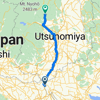
Day 2 Koga to Utsunomiya
A cycling route starting in Koga, Ibaraki, Japan.
Overview
About this route
Ran into some flooding on the river / bike route, but otherwise lovely, easy, flat.
- 5 h 46 min
- Duration
- 64.8 km
- Distance
- 118 m
- Ascent
- 17 m
- Descent
- 11.2 km/h
- Avg. speed
- ---
- Max. altitude

Continue with Bikemap
Use, edit, or download this cycling route
You would like to ride Day 2 Koga to Utsunomiya or customize it for your own trip? Here is what you can do with this Bikemap route:
Free features
- Save this route as favorite or in collections
- Copy & plan your own version of this route
- Sync your route with Garmin or Wahoo
Premium features
Free trial for 3 days, or one-time payment. More about Bikemap Premium.
- Navigate this route on iOS & Android
- Export a GPX / KML file of this route
- Create your custom printout (try it for free)
- Download this route for offline navigation
Discover more Premium features.
Get Bikemap PremiumFrom our community
Other popular routes starting in Koga
 Route from 256-2, Koga
- Distance
- 23.8 km
- Ascent
- 77 m
- Descent
- 91 m
- Location
- Koga, Ibaraki, Japan
 koga -> sakai
- Distance
- 19 km
- Ascent
- 91 m
- Descent
- 99 m
- Location
- Koga, Ibaraki, Japan
 Sakama, Koga à Kinugawaonsentaki, Nikko
- Distance
- 105.6 km
- Ascent
- 695 m
- Descent
- 337 m
- Location
- Koga, Ibaraki, Japan
 ココファーム
- Distance
- 38 km
- Ascent
- 145 m
- Descent
- 66 m
- Location
- Koga, Ibaraki, Japan
 374, Sotono, Kazo-Shi to 18-1, Sakae 1-Chōme, Kuki-Shi
- Distance
- 13.2 km
- Ascent
- 10 m
- Descent
- 20 m
- Location
- Koga, Ibaraki, Japan
 Asakusa
- Distance
- 62.4 km
- Ascent
- 66 m
- Descent
- 83 m
- Location
- Koga, Ibaraki, Japan
 Day2, Koga to Utsunomiya 80km
- Distance
- 80.1 km
- Ascent
- 852 m
- Descent
- 619 m
- Location
- Koga, Ibaraki, Japan
 De 362, Minamiakatsuka, Nogi-Machi, Shimotsuga-Gun a 362, Minamiakatsuka, Nogi-Machi, Shimotsuga-Gun
- Distance
- 2.3 km
- Ascent
- 10 m
- Descent
- 11 m
- Location
- Koga, Ibaraki, Japan
Open it in the app