


Träning 27.11.2025
- 38.2 km
- 759 m
- 760 m
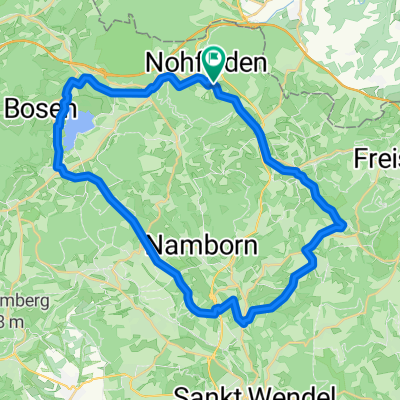
- Nohfelden, Saarland, Germany
A cycling route starting in Nohfelden, Saarland, Germany.
Overview
The tour starts in Türkismühle at the train station. Along country roads passing Sötem, Schwarzenbach, Ozenhausen, and Nonnweiler (a very nice 10% descent, unfortunately only 800m long) onto the Prims cycling path towards Hermeskeil (super good surface, constantly rolling hills but very moderate).
In Hermeskeil, a short detour into the pedestrian zone for ice cream, then onto the Ruwer-Höhen cycling path and follow it to Trier (from Reinsfeld it's almost all downhill).
From Trier Ruwer it gets a bit unpleasant as you first have to ride on the main road (Ruwerer Straße) and then on side paths with poor asphalt to the Moselle (alternatively, you can take the train here in Trier at the main station).
Then along the Moselle (unfortunately not such a great surface in Trier) and onto the Moselradweg to the Saar confluence and along the Saar to Saarburg (very nice between Kanzern and Schoden along the wild Saar, instead of the shipping Saar).
In Saarburg our strength left us G
created this 15 years ago
Route quality
Path
65.8 km
(63 %)
Track
9.4 km
(9 %)
Paved
92 km
(88 %)
Unpaved
8.4 km
(8 %)
Asphalt
78.4 km
(75 %)
Paved (undefined)
12.5 km
(12 %)
Continue with Bikemap
You would like to ride Dia-Radtour 2010 or customize it for your own trip? Here is what you can do with this Bikemap route:
Free trial for 3 days, or one-time payment. More about Bikemap Premium.
Discover more Premium features.
Get Bikemap PremiumFrom our community
Open it in the app


