
Grandes Alpes_Kudrna_Etapa2
A cycling route starting in Combloux, Auvergne-Rhône-Alpes, France.
Overview
About this route
The more information you write here, the more useful it will be for other users.<br /><br />* Course of the route.<br />* What is special about this route?<br />* Why would you recommend this route?<br />* What did you like the most here?<br />* Etc.
- -:--
- Duration
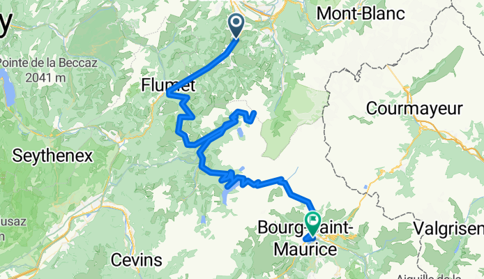
- 113.2 km
- Distance
- 2,667 m
- Ascent
- 2,930 m
- Descent
- ---
- Avg. speed
- ---
- Max. altitude
Route highlights
Points of interest along the route
Point of interest after 25.9 km
Col des Saisies (1650m)
Point of interest after 49 km
Col du Joly (1989m)
Point of interest after 91.5 km
Cormet de Roselend (1967m)
Continue with Bikemap
Use, edit, or download this cycling route
You would like to ride Grandes Alpes_Kudrna_Etapa2 or customize it for your own trip? Here is what you can do with this Bikemap route:
Free features
- Save this route as favorite or in collections
- Copy & plan your own version of this route
- Split it into stages to create a multi-day tour
- Sync your route with Garmin or Wahoo
Premium features
Free trial for 3 days, or one-time payment. More about Bikemap Premium.
- Navigate this route on iOS & Android
- Export a GPX / KML file of this route
- Create your custom printout (try it for free)
- Download this route for offline navigation
Discover more Premium features.
Get Bikemap PremiumFrom our community
Other popular routes starting in Combloux
 High Alps - Day 2 - Megeve to St Francois Longchamp
- Distance
- 95.4 km
- Ascent
- 2,189 m
- Descent
- 1,786 m
- Location
- Combloux, Auvergne-Rhône-Alpes, France
 Arafis
- Distance
- 97.2 km
- Ascent
- 2,299 m
- Descent
- 2,290 m
- Location
- Combloux, Auvergne-Rhône-Alpes, France
 2012-08-12 Demi Quartier-Col De Saises-Col Du Pre-Cormet De Roselend-Bourg St.Maurice
- Distance
- 96.4 km
- Ascent
- 2,163 m
- Descent
- 2,426 m
- Location
- Combloux, Auvergne-Rhône-Alpes, France
 Transalpine (10) Megève - Bourg St. Maurice
- Distance
- 91.7 km
- Ascent
- 1,935 m
- Descent
- 2,206 m
- Location
- Combloux, Auvergne-Rhône-Alpes, France
 Grandes Alpes_Kudrna_Etapa2
- Distance
- 113.2 km
- Ascent
- 2,667 m
- Descent
- 2,930 m
- Location
- Combloux, Auvergne-Rhône-Alpes, France
 Megève Morzine short way
- Distance
- 55.3 km
- Ascent
- 828 m
- Descent
- 892 m
- Location
- Combloux, Auvergne-Rhône-Alpes, France
 Megève-Morzine Tdf estimate
- Distance
- 105.4 km
- Ascent
- 2,495 m
- Descent
- 2,561 m
- Location
- Combloux, Auvergne-Rhône-Alpes, France
 4th day actual
- Distance
- 110.5 km
- Ascent
- 1,470 m
- Descent
- 2,033 m
- Location
- Combloux, Auvergne-Rhône-Alpes, France
Open it in the app