

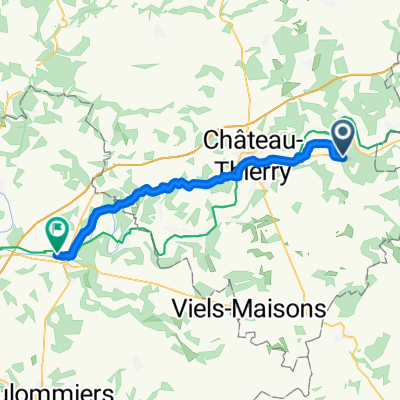
2020_07_11
A cycling route starting in Crézancy, Hauts-de-France, France.
Overview
About this route
- -:--
- Duration
- 31.3 km
- Distance
- 298 m
- Ascent
- 299 m
- Descent
- ---
- Avg. speed
- ---
- Max. altitude
Route quality
Waytypes & surfaces along the route
Waytypes
Road
17.9 km
(57 %)
Quiet road
3.8 km
(12 %)
Surfaces
Paved
3.1 km
(10 %)
Asphalt
3.1 km
(10 %)
Undefined
28.2 km
(90 %)
Continue with Bikemap
Use, edit, or download this cycling route
You would like to ride 2020_07_11 or customize it for your own trip? Here is what you can do with this Bikemap route:
Free features
- Save this route as favorite or in collections
- Copy & plan your own version of this route
- Sync your route with Garmin or Wahoo
Premium features
Free trial for 3 days, or one-time payment. More about Bikemap Premium.
- Navigate this route on iOS & Android
- Export a GPX / KML file of this route
- Create your custom printout (try it for free)
- Download this route for offline navigation
Discover more Premium features.
Get Bikemap PremiumFrom our community
Other popular routes starting in Crézancy
 2020_07_11
- Distance
- 31.3 km
- Ascent
- 298 m
- Descent
- 299 m
- Location
- Crézancy, Hauts-de-France, France
 29_10_2019
- Distance
- 50 km
- Ascent
- 400 m
- Descent
- 401 m
- Location
- Crézancy, Hauts-de-France, France
 2020_07_11
- Distance
- 73.4 km
- Ascent
- 60 m
- Descent
- 51 m
- Location
- Crézancy, Hauts-de-France, France
 Chateau Noger Artaud terug 69km
- Distance
- 69.6 km
- Ascent
- 236 m
- Descent
- 236 m
- Location
- Crézancy, Hauts-de-France, France
 Euro P1
- Distance
- 4,588.5 km
- Ascent
- 26,938 m
- Descent
- 26,940 m
- Location
- Crézancy, Hauts-de-France, France
 2019_10_23
- Distance
- 66.6 km
- Ascent
- 241 m
- Descent
- 236 m
- Location
- Crézancy, Hauts-de-France, France
 Crézancy - La Ferté-sous-Jouarre
- Distance
- 42.1 km
- Ascent
- 449 m
- Descent
- 553 m
- Location
- Crézancy, Hauts-de-France, France
 De Chemin du Bouvier, Monthurel à Place du Général de Gaulle 12, Dormans
- Distance
- 11.9 km
- Ascent
- 191 m
- Descent
- 192 m
- Location
- Crézancy, Hauts-de-France, France
Open it in the app