
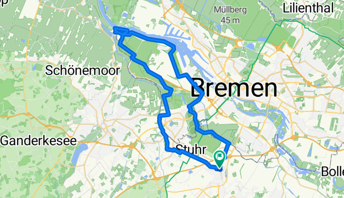
„Drei-Flüsse-Tour“ - Varreler Bäke, Ochtum, Weser
A cycling route starting in Stuhr, Lower Saxony, Germany.
Overview
About this route
- 3 h 51 min
- Duration
- 46.7 km
- Distance
- 3 m
- Ascent
- 10 m
- Descent
- 12.1 km/h
- Avg. speed
- ---
- Max. altitude

Route quality
Waytypes & surfaces along the route
Waytypes
Path
16.8 km
(36 %)
Quiet road
9.6 km
(21 %)
Surfaces
Paved
37 km
(79 %)
Unpaved
5.3 km
(11 %)
Asphalt
32.4 km
(69 %)
Paving stones
3.9 km
(8 %)
Continue with Bikemap
Use, edit, or download this cycling route
You would like to ride „Drei-Flüsse-Tour“ - Varreler Bäke, Ochtum, Weser or customize it for your own trip? Here is what you can do with this Bikemap route:
Free features
- Save this route as favorite or in collections
- Copy & plan your own version of this route
- Sync your route with Garmin or Wahoo
Premium features
Free trial for 3 days, or one-time payment. More about Bikemap Premium.
- Navigate this route on iOS & Android
- Export a GPX / KML file of this route
- Create your custom printout (try it for free)
- Download this route for offline navigation
Discover more Premium features.
Get Bikemap PremiumFrom our community
Other popular routes starting in Stuhr
 LANKENAU HOEFT
- Distance
- 29.2 km
- Ascent
- 20 m
- Descent
- 20 m
- Location
- Stuhr, Lower Saxony, Germany
 stuhrTour
- Distance
- 15.8 km
- Ascent
- 898 m
- Descent
- 944 m
- Location
- Stuhr, Lower Saxony, Germany
 Route-Stuhr-73
- Distance
- 72.9 km
- Ascent
- 165 m
- Descent
- 161 m
- Location
- Stuhr, Lower Saxony, Germany
 Weyhe - Syke - Bassum - Stühren - Gräfinghausen - Seckenhausen - Weyhe CLONED FROM ROUTE 1751855
- Distance
- 51.9 km
- Ascent
- 101 m
- Descent
- 104 m
- Location
- Stuhr, Lower Saxony, Germany
 „Drei-Flüsse-Tour“ - Varreler Bäke, Ochtum, Weser
- Distance
- 46.7 km
- Ascent
- 3 m
- Descent
- 10 m
- Location
- Stuhr, Lower Saxony, Germany
 Leeste-Erichshof-Hoher Berg-Syke
- Distance
- 29.3 km
- Ascent
- 66 m
- Descent
- 66 m
- Location
- Stuhr, Lower Saxony, Germany
 Sonntagsrunde
- Distance
- 40 km
- Ascent
- 91 m
- Descent
- 93 m
- Location
- Stuhr, Lower Saxony, Germany
 71er Runde (Stuhr, Kirchseelte, Weyhe)
- Distance
- 68.9 km
- Ascent
- 175 m
- Descent
- 174 m
- Location
- Stuhr, Lower Saxony, Germany
Open it in the app