

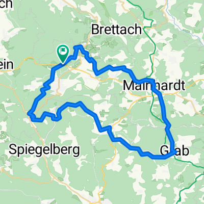
Rundweg von Neuhütten nach Schwäbisch Hall und zurück
A cycling route starting in Wüstenrot, Baden-Wurttemberg, Germany.
Overview
About this route
The route to Schwäbisch Hall is good for cycling. Three climbs need to be tackled. Coming from Hall along the B 14 and from Bibersfeld towards Wielandsweiler. The third climb is from Böhringsweiler over Hals to Wüstenrot. Overall, the route is challenging and should only be ridden by experienced cyclists.
- -:--
- Duration
- 62.8 km
- Distance
- 706 m
- Ascent
- 735 m
- Descent
- ---
- Avg. speed
- 513 m
- Max. altitude

Route quality
Waytypes & surfaces along the route
Waytypes
Track
25.1 km
(40 %)
Quiet road
15.7 km
(25 %)
Surfaces
Paved
33.9 km
(54 %)
Unpaved
13.2 km
(21 %)
Asphalt
28.9 km
(46 %)
Gravel
6.9 km
(11 %)
Continue with Bikemap
Use, edit, or download this cycling route
You would like to ride Rundweg von Neuhütten nach Schwäbisch Hall und zurück or customize it for your own trip? Here is what you can do with this Bikemap route:
Free features
- Save this route as favorite or in collections
- Copy & plan your own version of this route
- Sync your route with Garmin or Wahoo
Premium features
Free trial for 3 days, or one-time payment. More about Bikemap Premium.
- Navigate this route on iOS & Android
- Export a GPX / KML file of this route
- Create your custom printout (try it for free)
- Download this route for offline navigation
Discover more Premium features.
Get Bikemap PremiumFrom our community
Other popular routes starting in Wüstenrot
 Wüstenrot-Mainhardt-Wüstenrot
- Distance
- 28 km
- Ascent
- 243 m
- Descent
- 244 m
- Location
- Wüstenrot, Baden-Wurttemberg, Germany
 Rundweg von Neuhütten nach Schwäbisch Hall und zurück
- Distance
- 62.8 km
- Ascent
- 706 m
- Descent
- 735 m
- Location
- Wüstenrot, Baden-Wurttemberg, Germany
 Löwensteiner Berge (Steinknickle-Limes-Tobelschlucht-Silberstollen)
- Distance
- 38.9 km
- Ascent
- 656 m
- Descent
- 656 m
- Location
- Wüstenrot, Baden-Wurttemberg, Germany
 Kurzstrecke Rundweg Neuhütten - Mainhardt - Wüstenrot
- Distance
- 23.5 km
- Ascent
- 312 m
- Descent
- 314 m
- Location
- Wüstenrot, Baden-Wurttemberg, Germany
 Löwensteiner Berge (Steinknickle-Limes-Tobelschlucht-Silberstollen)
- Distance
- 38.9 km
- Ascent
- 687 m
- Descent
- 687 m
- Location
- Wüstenrot, Baden-Wurttemberg, Germany
 PV_IVB_Tour5-Hoch-Oben-39km-925hm
- Distance
- 38.7 km
- Ascent
- 609 m
- Descent
- 609 m
- Location
- Wüstenrot, Baden-Wurttemberg, Germany
 Neuhütten-Heilbronner Weg-Weinsberger Tal
- Distance
- 50.5 km
- Ascent
- 675 m
- Descent
- 787 m
- Location
- Wüstenrot, Baden-Wurttemberg, Germany
 Finsterrot: Dachsi Naturerlebnispfad
- Distance
- 2.7 km
- Ascent
- 39 m
- Descent
- 43 m
- Location
- Wüstenrot, Baden-Wurttemberg, Germany
Open it in the app