

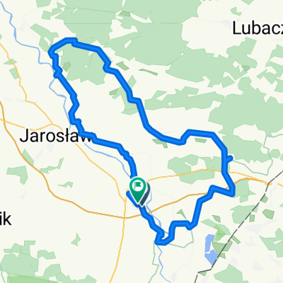
Unnamed Road do , Wyszatyce
A cycling route starting in Sośnica, Subcarpathian Voivodeship, Poland.
Overview
About this route
- 3 h 21 min
- Duration
- 73.1 km
- Distance
- 307 m
- Ascent
- 308 m
- Descent
- 21.8 km/h
- Avg. speed
- ---
- Max. altitude

Route quality
Waytypes & surfaces along the route
Waytypes
Road
43.9 km
(60 %)
Path
16.8 km
(23 %)
Surfaces
Paved
63.6 km
(87 %)
Asphalt
62.9 km
(86 %)
Concrete
0.7 km
(1 %)
Undefined
9.5 km
(13 %)
Continue with Bikemap
Use, edit, or download this cycling route
You would like to ride Unnamed Road do , Wyszatyce or customize it for your own trip? Here is what you can do with this Bikemap route:
Free features
- Save this route as favorite or in collections
- Copy & plan your own version of this route
- Sync your route with Garmin or Wahoo
Premium features
Free trial for 3 days, or one-time payment. More about Bikemap Premium.
- Navigate this route on iOS & Android
- Export a GPX / KML file of this route
- Create your custom printout (try it for free)
- Download this route for offline navigation
Discover more Premium features.
Get Bikemap PremiumFrom our community
Other popular routes starting in Sośnica
 Route in Gmina Radymno
- Distance
- 109 km
- Ascent
- 255 m
- Descent
- 256 m
- Location
- Sośnica, Subcarpathian Voivodeship, Poland
 Unnamed Road do , Wyszatyce
- Distance
- 73.1 km
- Ascent
- 307 m
- Descent
- 308 m
- Location
- Sośnica, Subcarpathian Voivodeship, Poland
 Recovered Route
- Distance
- 39.8 km
- Ascent
- 133 m
- Descent
- 117 m
- Location
- Sośnica, Subcarpathian Voivodeship, Poland
 Radymno gmina, Radymno do A4, Stubno
- Distance
- 7.8 km
- Ascent
- 15 m
- Descent
- 3 m
- Location
- Sośnica, Subcarpathian Voivodeship, Poland
 93A, Walawa do Wacławice
- Distance
- 11.3 km
- Ascent
- 120 m
- Descent
- 71 m
- Location
- Sośnica, Subcarpathian Voivodeship, Poland
 Gdańsk
- Distance
- 665.8 km
- Ascent
- 2,376 m
- Descent
- 2,554 m
- Location
- Sośnica, Subcarpathian Voivodeship, Poland
 Unnamed Road do Przemyśl
- Distance
- 19 km
- Ascent
- 127 m
- Descent
- 114 m
- Location
- Sośnica, Subcarpathian Voivodeship, Poland
 dzien 7
- Distance
- 67.3 km
- Ascent
- 172 m
- Descent
- 137 m
- Location
- Sośnica, Subcarpathian Voivodeship, Poland
Open it in the app