

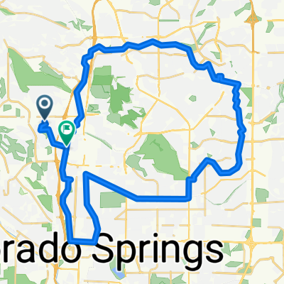
Fundraise Ride Day 3 - 50 mi
A cycling route starting in Colorado Springs, Colorado, United States.
Overview
About this route
- -:--
- Duration
- 80.3 km
- Distance
- 880 m
- Ascent
- 879 m
- Descent
- ---
- Avg. speed
- ---
- Max. altitude
Route quality
Waytypes & surfaces along the route
Waytypes
Quiet road
38.9 km
(48 %)
Road
16.3 km
(20 %)
Surfaces
Paved
35.4 km
(44 %)
Asphalt
26.1 km
(32 %)
Concrete
7.8 km
(10 %)
Continue with Bikemap
Use, edit, or download this cycling route
You would like to ride Fundraise Ride Day 3 - 50 mi or customize it for your own trip? Here is what you can do with this Bikemap route:
Free features
- Save this route as favorite or in collections
- Copy & plan your own version of this route
- Split it into stages to create a multi-day tour
- Sync your route with Garmin or Wahoo
Premium features
Free trial for 3 days, or one-time payment. More about Bikemap Premium.
- Navigate this route on iOS & Android
- Export a GPX / KML file of this route
- Create your custom printout (try it for free)
- Download this route for offline navigation
Discover more Premium features.
Get Bikemap PremiumFrom our community
Other popular routes starting in Colorado Springs
 Route to Colorado Springs
- Distance
- 161.7 km
- Ascent
- 3,685 m
- Descent
- 3,709 m
- Location
- Colorado Springs, Colorado, United States
 Lengthy ride through Colorado Springs
- Distance
- 35.4 km
- Ascent
- 248 m
- Descent
- 249 m
- Location
- Colorado Springs, Colorado, United States
 Fundraise Ride Day 3 - 50 mi
- Distance
- 80.3 km
- Ascent
- 880 m
- Descent
- 879 m
- Location
- Colorado Springs, Colorado, United States
 Homestead loop
- Distance
- 44.8 km
- Ascent
- 299 m
- Descent
- 355 m
- Location
- Colorado Springs, Colorado, United States
 lunch ride paved old stage
- Distance
- 13.7 km
- Ascent
- 298 m
- Descent
- 297 m
- Location
- Colorado Springs, Colorado, United States
 Rockrimmon, Colorado Springs to Rockrimmon, Colorado Springs
- Distance
- 8.8 km
- Ascent
- 172 m
- Descent
- 174 m
- Location
- Colorado Springs, Colorado, United States
 lunch ride gold camp
- Distance
- 17 km
- Ascent
- 345 m
- Descent
- 347 m
- Location
- Colorado Springs, Colorado, United States
 Pueblo fifty
- Distance
- 81.2 km
- Ascent
- 35 m
- Descent
- 501 m
- Location
- Colorado Springs, Colorado, United States
Open it in the app