

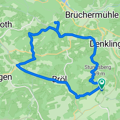
Vollgasrunde: durch die "Bröltäler"
A cycling route starting in Waldbröl, North Rhine-Westphalia, Germany.
Overview
About this route
- -:--
- Duration
- 43.3 km
- Distance
- 255 m
- Ascent
- 293 m
- Descent
- ---
- Avg. speed
- 305 m
- Max. altitude

Route quality
Waytypes & surfaces along the route
Waytypes
Path
13.8 km
(32 %)
Cycleway
4.3 km
(10 %)
Surfaces
Paved
31.6 km
(73 %)
Unpaved
0.4 km
(1 %)
Asphalt
31.1 km
(72 %)
Paved (undefined)
0.4 km
(1 %)
Continue with Bikemap
Use, edit, or download this cycling route
You would like to ride Vollgasrunde: durch die "Bröltäler" or customize it for your own trip? Here is what you can do with this Bikemap route:
Free features
- Save this route as favorite or in collections
- Copy & plan your own version of this route
- Sync your route with Garmin or Wahoo
Premium features
Free trial for 3 days, or one-time payment. More about Bikemap Premium.
- Navigate this route on iOS & Android
- Export a GPX / KML file of this route
- Create your custom printout (try it for free)
- Download this route for offline navigation
Discover more Premium features.
Get Bikemap PremiumFrom our community
Other popular routes starting in Waldbröl
 Die flachen 100km
- Distance
- 98.7 km
- Ascent
- 499 m
- Descent
- 499 m
- Location
- Waldbröl, North Rhine-Westphalia, Germany
 ... mal zu Fuß?
- Distance
- 9.9 km
- Ascent
- 214 m
- Descent
- 214 m
- Location
- Waldbröl, North Rhine-Westphalia, Germany
 Waldbröl - Hülstert - Denklingen - Oberbierenbach - Schloß Homburg - Nümbrecht - Waldbröl
- Distance
- 36.2 km
- Ascent
- 468 m
- Descent
- 468 m
- Location
- Waldbröl, North Rhine-Westphalia, Germany
 Hambuchen-Herchen-Schladern-Hamm-Wissen
- Distance
- 80.9 km
- Ascent
- 866 m
- Descent
- 909 m
- Location
- Waldbröl, North Rhine-Westphalia, Germany
 Im Reich des Borkenkäfers
- Distance
- 8 km
- Ascent
- 256 m
- Descent
- 254 m
- Location
- Waldbröl, North Rhine-Westphalia, Germany
 Auf dem Holzweg
- Distance
- 7.3 km
- Ascent
- 216 m
- Descent
- 216 m
- Location
- Waldbröl, North Rhine-Westphalia, Germany
 Olper Straße nach Auf dem Kamp
- Distance
- 17.7 km
- Ascent
- 299 m
- Descent
- 303 m
- Location
- Waldbröl, North Rhine-Westphalia, Germany
 Auf dem Berg, Waldbröl nach Auf dem Berg, Waldbröl
- Distance
- 15.9 km
- Ascent
- 270 m
- Descent
- 270 m
- Location
- Waldbröl, North Rhine-Westphalia, Germany
Open it in the app