

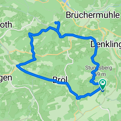
Tour de Bröl
A cycling route starting in Waldbröl, North Rhine-Westphalia, Germany.
Overview
About this route
Always passing by the Bröl - Well, almost always, because we also have to go home and water doesn't flow uphill.
We start in Bladersbach, follow the village stream to the Waldbrölbach. Along it until the point where the Hoburg Bröl flows into the Waldbrölbach. We go up the Homburg Bröltal to Rötgen, where we leave the Bröl to return to the starting point.
- -:--
- Duration
- 31.9 km
- Distance
- 280 m
- Ascent
- 280 m
- Descent
- ---
- Avg. speed
- ---
- Max. altitude

Route quality
Waytypes & surfaces along the route
Waytypes
Path
17.2 km
(54 %)
Quiet road
8.9 km
(28 %)
Surfaces
Paved
26.2 km
(82 %)
Asphalt
25.8 km
(81 %)
Paved (undefined)
0.3 km
(1 %)
Undefined
5.7 km
(18 %)
Continue with Bikemap
Use, edit, or download this cycling route
You would like to ride Tour de Bröl or customize it for your own trip? Here is what you can do with this Bikemap route:
Free features
- Save this route as favorite or in collections
- Copy & plan your own version of this route
- Sync your route with Garmin or Wahoo
Premium features
Free trial for 3 days, or one-time payment. More about Bikemap Premium.
- Navigate this route on iOS & Android
- Export a GPX / KML file of this route
- Create your custom printout (try it for free)
- Download this route for offline navigation
Discover more Premium features.
Get Bikemap PremiumFrom our community
Other popular routes starting in Waldbröl
 Auf dem Berg, Waldbröl nach Auf dem Berg, Waldbröl
- Distance
- 15.9 km
- Ascent
- 270 m
- Descent
- 270 m
- Location
- Waldbröl, North Rhine-Westphalia, Germany
 Die flachen 100km
- Distance
- 98.7 km
- Ascent
- 499 m
- Descent
- 499 m
- Location
- Waldbröl, North Rhine-Westphalia, Germany
 Im Reich des Borkenkäfers
- Distance
- 8 km
- Ascent
- 256 m
- Descent
- 254 m
- Location
- Waldbröl, North Rhine-Westphalia, Germany
 26.03.20 LF14 MJ6 KF26
- Distance
- 33.8 km
- Ascent
- 697 m
- Descent
- 697 m
- Location
- Waldbröl, North Rhine-Westphalia, Germany
 Olper Straße nach Auf dem Kamp
- Distance
- 17.7 km
- Ascent
- 299 m
- Descent
- 303 m
- Location
- Waldbröl, North Rhine-Westphalia, Germany
 Waldbröl - Hülstert - Denklingen - Oberbierenbach - Schloß Homburg - Nümbrecht - Waldbröl
- Distance
- 36.2 km
- Ascent
- 468 m
- Descent
- 468 m
- Location
- Waldbröl, North Rhine-Westphalia, Germany
 Kurze Runde
- Distance
- 5 km
- Ascent
- 117 m
- Descent
- 117 m
- Location
- Waldbröl, North Rhine-Westphalia, Germany
 Auf dem Holzweg
- Distance
- 7.3 km
- Ascent
- 216 m
- Descent
- 216 m
- Location
- Waldbröl, North Rhine-Westphalia, Germany
Open it in the app