

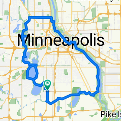
B2B00814 55409 > 55455 via Park Ave, Midtown Greenway
A cycling route starting in Richfield, Minnesota, United States.
Overview
About this route
Approx. 5 miles each way.
- -:--
- Duration
- 8.7 km
- Distance
- 63 m
- Ascent
- 64 m
- Descent
- ---
- Avg. speed
- ---
- Max. altitude
Route highlights
Points of interest along the route
Point of interest after 3.2 km
Enter onto the Midtown Greenway using the graded trail.
Point of interest after 5.2 km
Cross Hiawatha at the Sabo Bridge.
Point of interest after 5.6 km
Take the LRT trail north.
Point of interest after 6.6 km
Exit the trail at Cedar Ave S.
Point of interest after 7.7 km
Take the bicycle lane through campus to reach the upper deck on Washington Ave, which crosses the river.
Continue with Bikemap
Use, edit, or download this cycling route
You would like to ride B2B00814 55409 > 55455 via Park Ave, Midtown Greenway or customize it for your own trip? Here is what you can do with this Bikemap route:
Free features
- Save this route as favorite or in collections
- Copy & plan your own version of this route
- Sync your route with Garmin or Wahoo
Premium features
Free trial for 3 days, or one-time payment. More about Bikemap Premium.
- Navigate this route on iOS & Android
- Export a GPX / KML file of this route
- Create your custom printout (try it for free)
- Download this route for offline navigation
Discover more Premium features.
Get Bikemap PremiumFrom our community
Other popular routes starting in Richfield
 MoA - Grand Route - MoA
- Distance
- 61.9 km
- Ascent
- 156 m
- Descent
- 158 m
- Location
- Richfield, Minnesota, United States
 31 Miles South to North, to Victory Memorial & Minnehaha
- Distance
- 50.9 km
- Ascent
- 124 m
- Descent
- 124 m
- Location
- Richfield, Minnesota, United States
 30 miler
- Distance
- 48.5 km
- Ascent
- 308 m
- Descent
- 310 m
- Location
- Richfield, Minnesota, United States
 East 46th Street 180, Minneapolis to Union Depot, Saint Paul
- Distance
- 22.2 km
- Ascent
- 153 m
- Descent
- 185 m
- Location
- Richfield, Minnesota, United States
 B2B00042 55419 > 55422 via Greenway, Cedar Lake, and Theo Wirth
- Distance
- 13.3 km
- Ascent
- 61 m
- Descent
- 59 m
- Location
- Richfield, Minnesota, United States
 B2B00056 55407>55122 via Mnnhaha Pwy, Bg Rvrs Trl
- Distance
- 17.7 km
- Ascent
- 99 m
- Descent
- 109 m
- Location
- Richfield, Minnesota, United States
 B2B00920 55407>55438 via Portland, Mnnha Pwy, Logan, Hylund Prk
- Distance
- 23.7 km
- Ascent
- 98 m
- Descent
- 95 m
- Location
- Richfield, Minnesota, United States
 Perfect Circle Minneapolis Bike Route
- Distance
- 36.4 km
- Ascent
- 117 m
- Descent
- 117 m
- Location
- Richfield, Minnesota, United States
Open it in the app