

Loire 1.Tag
A cycling route starting in Olivet, Centre-Val de Loire, France.
Overview
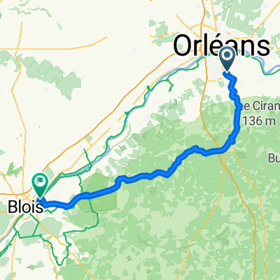
About this route
Start in Olivet. You can leave your car at the campsite there.
- -:--
- Duration
- 44.1 km
- Distance
- 48 m
- Ascent
- 66 m
- Descent
- ---
- Avg. speed
- ---
- Max. altitude
Continue with Bikemap
Use, edit, or download this cycling route
You would like to ride Loire 1.Tag or customize it for your own trip? Here is what you can do with this Bikemap route:
Free features
- Save this route as favorite or in collections
- Copy & plan your own version of this route
- Sync your route with Garmin or Wahoo
Premium features
Free trial for 3 days, or one-time payment. More about Bikemap Premium.
- Navigate this route on iOS & Android
- Export a GPX / KML file of this route
- Create your custom printout (try it for free)
- Download this route for offline navigation
Discover more Premium features.
Get Bikemap PremiumFrom our community
Other popular routes starting in Olivet
 Olivet-Meung-Olivet
- Distance
- 38.7 km
- Ascent
- 43 m
- Descent
- 42 m
- Location
- Olivet, Centre-Val de Loire, France
 OLVT2ARGTN
- Distance
- 166.3 km
- Ascent
- 350 m
- Descent
- 341 m
- Location
- Olivet, Centre-Val de Loire, France
 Orleans-Olivet - Montlouis-sur Loire
- Distance
- 109 km
- Ascent
- 71 m
- Descent
- 125 m
- Location
- Olivet, Centre-Val de Loire, France
 Petit tour Ardon+ nationale 45min
- Distance
- 24.4 km
- Ascent
- 46 m
- Descent
- 47 m
- Location
- Olivet, Centre-Val de Loire, France
 Loire völgye (Orléans-Blois)
- Distance
- 72.5 km
- Ascent
- 123 m
- Descent
- 148 m
- Location
- Olivet, Centre-Val de Loire, France
 Loire 1.Tag
- Distance
- 44.1 km
- Ascent
- 48 m
- Descent
- 66 m
- Location
- Olivet, Centre-Val de Loire, France
 PB ST2
- Distance
- 119.2 km
- Ascent
- 127 m
- Descent
- 168 m
- Location
- Olivet, Centre-Val de Loire, France
 Ziua 1: Olivet - Briare
- Distance
- 98.4 km
- Ascent
- 157 m
- Descent
- 122 m
- Location
- Olivet, Centre-Val de Loire, France
Open it in the app