

route des crêtes (cassis-la ciotat)
A cycling route starting in Marseille 11, Provence-Alpes-Côte d'Azur Region, France.
Overview
About this route
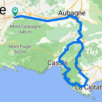
montée avec un fort pourcentage (pas de la Colle) vers la route des crêtes par Cassis.
retour depuis la Ciotat par le pas de Belle Fille puis le pas d' Ouillier.
- -:--
- Duration
- 68.6 km
- Distance
- 923 m
- Ascent
- 919 m
- Descent
- ---
- Avg. speed
- ---
- Max. altitude
Continue with Bikemap
Use, edit, or download this cycling route
You would like to ride route des crêtes (cassis-la ciotat) or customize it for your own trip? Here is what you can do with this Bikemap route:
Free features
- Save this route as favorite or in collections
- Copy & plan your own version of this route
- Sync your route with Garmin or Wahoo
Premium features
Free trial for 3 days, or one-time payment. More about Bikemap Premium.
- Navigate this route on iOS & Android
- Export a GPX / KML file of this route
- Create your custom printout (try it for free)
- Download this route for offline navigation
Discover more Premium features.
Get Bikemap PremiumFrom our community
Other popular routes starting in Marseille 11
 Gineste-Carnoux-Roquefort-col de l' Ange-Gèmenos
- Distance
- 61 km
- Ascent
- 653 m
- Descent
- 653 m
- Location
- Marseille 11, Provence-Alpes-Côte d'Azur Region, France
 Vers l'est
- Distance
- 121.4 km
- Ascent
- 1,196 m
- Descent
- 1,200 m
- Location
- Marseille 11, Provence-Alpes-Côte d'Azur Region, France
 La Ciotat par la Route des Crètes
- Distance
- 66.5 km
- Ascent
- 870 m
- Descent
- 869 m
- Location
- Marseille 11, Provence-Alpes-Côte d'Azur Region, France
 Projet II
- Distance
- 118 km
- Ascent
- 1,284 m
- Descent
- 1,284 m
- Location
- Marseille 11, Provence-Alpes-Côte d'Azur Region, France
 Sprint du Garlaban
- Distance
- 51 km
- Ascent
- 613 m
- Descent
- 614 m
- Location
- Marseille 11, Provence-Alpes-Côte d'Azur Region, France
 Marseille - Géménos - Plan d'Aups - Auriol - Roquevaire - Marseille (via Éoures)
- Distance
- 71.3 km
- Ascent
- 853 m
- Descent
- 853 m
- Location
- Marseille 11, Provence-Alpes-Côte d'Azur Region, France
 Mont Saint-Cyr
- Distance
- 3.4 km
- Ascent
- 540 m
- Descent
- 23 m
- Location
- Marseille 11, Provence-Alpes-Côte d'Azur Region, France
 Puyloubier par le Petit Galibier
- Distance
- 109.9 km
- Ascent
- 957 m
- Descent
- 957 m
- Location
- Marseille 11, Provence-Alpes-Côte d'Azur Region, France
Open it in the app