Podbranc-Myjava-Javorina-Bradlo
A cycling route starting in Senica, Trnava Region, Slovakia.
Overview
About this route
- 7 h 54 min
- Duration
- 95.9 km
- Distance
- 1,451 m
- Ascent
- 1,453 m
- Descent
- 12.1 km/h
- Avg. speed
- ---
- Max. altitude
Route photos
Route quality
Waytypes & surfaces along the route
Waytypes
Road
72.9 km
(76 %)
Track
8.6 km
(9 %)
Surfaces
Paved
16.3 km
(17 %)
Unpaved
8.6 km
(9 %)
Asphalt
16.3 km
(17 %)
Gravel
8.6 km
(9 %)
Undefined
71 km
(74 %)
Continue with Bikemap
Use, edit, or download this cycling route
You would like to ride Podbranc-Myjava-Javorina-Bradlo or customize it for your own trip? Here is what you can do with this Bikemap route:
Free features
- Save this route as favorite or in collections
- Copy & plan your own version of this route
- Split it into stages to create a multi-day tour
- Sync your route with Garmin or Wahoo
Premium features
Free trial for 3 days, or one-time payment. More about Bikemap Premium.
- Navigate this route on iOS & Android
- Export a GPX / KML file of this route
- Create your custom printout (try it for free)
- Download this route for offline navigation
Discover more Premium features.
Get Bikemap PremiumFrom our community
Other popular routes starting in Senica
- B05 Karpatsky prechod
- Distance
- 57.5 km
- Ascent
- 991 m
- Descent
- 1,072 m
- Location
- Senica, Trnava Region, Slovakia
- SE – BA
- Distance
- 106.2 km
- Ascent
- 1,276 m
- Descent
- 1,346 m
- Location
- Senica, Trnava Region, Slovakia
- asfaltka v humencovie lesoch
- Distance
- 32.9 km
- Ascent
- 169 m
- Descent
- 172 m
- Location
- Senica, Trnava Region, Slovakia
- kpcovita trasa
- Distance
- 20 km
- Ascent
- 307 m
- Descent
- 109 m
- Location
- Senica, Trnava Region, Slovakia
- 1126, Lopašov do Chropov
- Distance
- 22.9 km
- Ascent
- 236 m
- Descent
- 258 m
- Location
- Senica, Trnava Region, Slovakia
- Senica - Radošovce - Holíč
- Distance
- 24.1 km
- Ascent
- 143 m
- Descent
- 173 m
- Location
- Senica, Trnava Region, Slovakia
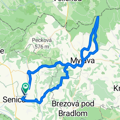
- malý okruh Jablonica
- Distance
- 28.6 km
- Ascent
- 562 m
- Descent
- 560 m
- Location
- Senica, Trnava Region, Slovakia
- Cyklotrasa zo Senice na Veľkú Javorinu a späť
- Distance
- 92.7 km
- Ascent
- 1,160 m
- Descent
- 1,160 m
- Location
- Senica, Trnava Region, Slovakia
Open it in the app