
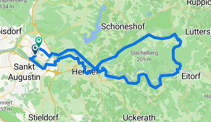
Siegburg - Eitorf - Siegburg
A cycling route starting in Siegburg, North Rhine-Westphalia, Germany.
Overview
About this route
Siegburg, Buisdorf, Hennef, Eitorf, Schmelztal, Bröl, Siegburg
- -:--
- Duration
- 50 km
- Distance
- 462 m
- Ascent
- 411 m
- Descent
- ---
- Avg. speed
- 279 m
- Avg. speed
Route quality
Waytypes & surfaces along the route
Waytypes
Busy road
16.4 km
(33 %)
Path
10.7 km
(21 %)
Surfaces
Paved
44.8 km
(90 %)
Unpaved
0.6 km
(1 %)
Asphalt
44.4 km
(89 %)
Gravel
0.6 km
(1 %)
Continue with Bikemap
Use, edit, or download this cycling route
You would like to ride Siegburg - Eitorf - Siegburg or customize it for your own trip? Here is what you can do with this Bikemap route:
Free features
- Save this route as favorite or in collections
- Copy & plan your own version of this route
- Sync your route with Garmin or Wahoo
Premium features
Free trial for 3 days, or one-time payment. More about Bikemap Premium.
- Navigate this route on iOS & Android
- Export a GPX / KML file of this route
- Create your custom printout (try it for free)
- Download this route for offline navigation
Discover more Premium features.
Get Bikemap PremiumFrom our community
Other popular routes starting in Siegburg
 Am Stadion 1, Siegburg nach Am Stadion 1, Siegburg
- Distance
- 125.2 km
- Ascent
- 2,714 m
- Descent
- 2,729 m
- Location
- Siegburg, North Rhine-Westphalia, Germany
 Blau-Weiss-Permanente des RV 1894 Siegburg
- Distance
- 64.5 km
- Ascent
- 514 m
- Descent
- 514 m
- Location
- Siegburg, North Rhine-Westphalia, Germany
 BRT2021-SA: Vom Rhein zur Sieg - RTF des BRT 2021 in Siegburg - 43 km Strecke
- Distance
- 43.1 km
- Ascent
- 1,009 m
- Descent
- 1,009 m
- Location
- Siegburg, North Rhine-Westphalia, Germany
 Siegburg Gevelsberg
- Distance
- 88 km
- Ascent
- 1,203 m
- Descent
- 1,069 m
- Location
- Siegburg, North Rhine-Westphalia, Germany
 Rund um die Wahnbachtalsperre
- Distance
- 24.6 km
- Ascent
- 308 m
- Descent
- 308 m
- Location
- Siegburg, North Rhine-Westphalia, Germany
 Von Siegburg bis Lahnstein
- Distance
- 92.5 km
- Ascent
- 541 m
- Descent
- 545 m
- Location
- Siegburg, North Rhine-Westphalia, Germany
 2. CTF Wahnbachtour 55
- Distance
- 54.5 km
- Ascent
- 535 m
- Descent
- 533 m
- Location
- Siegburg, North Rhine-Westphalia, Germany
 BRT2021-FR: Rund um den Flugplatz Konrad Adenauer - RTF des BRT 2021 in Siegburg - 75 km Strecke
- Distance
- 74.7 km
- Ascent
- 1,961 m
- Descent
- 1,961 m
- Location
- Siegburg, North Rhine-Westphalia, Germany
Open it in the app