SE – BA
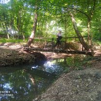
A cycling route starting in Senica, Trnava Region, Slovakia.
Overview
About this route
- -:--
- Duration
- 105.3 km
- Distance
- 1,245 m
- Ascent
- 1,315 m
- Descent
- ---
- Avg. speed
- ---
- Max. altitude
Route quality
Waytypes & surfaces along the route
Waytypes
Track
25.3 km
(24 %)
Quiet road
19 km
(18 %)
Surfaces
Paved
60 km
(57 %)
Unpaved
23.2 km
(22 %)
Asphalt
55.8 km
(53 %)
Gravel
8.4 km
(8 %)
Continue with Bikemap
Use, edit, or download this cycling route
You would like to ride SE – BA or customize it for your own trip? Here is what you can do with this Bikemap route:
Free features
- Save this route as favorite or in collections
- Copy & plan your own version of this route
- Split it into stages to create a multi-day tour
- Sync your route with Garmin or Wahoo
Premium features
Free trial for 3 days, or one-time payment. More about Bikemap Premium.
- Navigate this route on iOS & Android
- Export a GPX / KML file of this route
- Create your custom printout (try it for free)
- Download this route for offline navigation
Discover more Premium features.
Get Bikemap PremiumFrom our community
Other popular routes starting in Senica
- kpcovita trasa
- Distance
- 20 km
- Ascent
- 307 m
- Descent
- 109 m
- Location
- Senica, Trnava Region, Slovakia
- SE – BA
- Distance
- 106.2 km
- Ascent
- 1,276 m
- Descent
- 1,346 m
- Location
- Senica, Trnava Region, Slovakia
- Senica - Prietrž (Vodná nádrž)
- Distance
- 7.4 km
- Ascent
- 139 m
- Descent
- 96 m
- Location
- Senica, Trnava Region, Slovakia
- Senica - Rozhľadňa Žalostiná
- Distance
- 21.7 km
- Ascent
- 490 m
- Descent
- 79 m
- Location
- Senica, Trnava Region, Slovakia
- B05 Karpatsky prechod
- Distance
- 57.5 km
- Ascent
- 991 m
- Descent
- 1,072 m
- Location
- Senica, Trnava Region, Slovakia
- Senica - Jablonica - Cerová - Rozbehy
- Distance
- 17.2 km
- Ascent
- 282 m
- Descent
- 44 m
- Location
- Senica, Trnava Region, Slovakia
- Podbranc-Myjava-Javorina-Bradlo
- Distance
- 95.9 km
- Ascent
- 1,451 m
- Descent
- 1,453 m
- Location
- Senica, Trnava Region, Slovakia
- Senica - Rozhľadňa Lipky
- Distance
- 16.5 km
- Ascent
- 342 m
- Descent
- 132 m
- Location
- Senica, Trnava Region, Slovakia
Open it in the app