- 105.6 km
- 1,583 m
- 1,582 m
- Monnetier-Mornex, Auvergne-Rhône-Alpes, France
Mont Saleve (F) - Genf
A cycling route starting in Monnetier-Mornex, Auvergne-Rhône-Alpes, France.
Overview
About this route
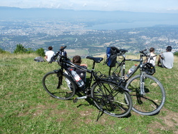
From the mountain, beautiful views of Geneva and the lake as well as the French Alps with Mont Blanc. On the mountain, you have the option to use the road with a road bike or to explore the mountain off-road with a mountain bike. At the top of the road, there are still long climbs. Naturally, there are wonderful descents until the rims heat up. After the mountain effort, a refreshing swim in the Rhone is well worth it.
- -:--
- Duration
- 40.1 km
- Distance
- 866 m
- Ascent
- 1,537 m
- Descent
- ---
- Avg. speed
- ---
- Max. altitude
created this 15 years ago
Route highlights
Points of interest along the route

Point of interest after 0.1 km
Mont Blanc

Point of interest after 0.1 km
Point of interest after 6.6 km

Point of interest after 6.6 km
Point of interest after 32.5 km

Point of interest after 32.5 km
Zusammenfluss Rhone und Arve

Point of interest after 33.5 km
Abkühlung in der Rhone
Continue with Bikemap
Use, edit, or download this cycling route
You would like to ride Mont Saleve (F) - Genf or customize it for your own trip? Here is what you can do with this Bikemap route:
Free features
- Save this route as favorite or in collections
- Copy & plan your own version of this route
- Sync your route with Garmin or Wahoo
Premium features
Free trial for 3 days, or one-time payment. More about Bikemap Premium.
- Navigate this route on iOS & Android
- Export a GPX / KML file of this route
- Create your custom printout (try it for free)
- Download this route for offline navigation
Discover more Premium features.
Get Bikemap PremiumFrom our community
Other popular routes starting in Monnetier-Mornex
- col de la ramaz 2
- La Muraz - La Croisette en 2 manches
- 7.5 km
- 606 m
- 62 m
- Monnetier-Mornex, Auvergne-Rhône-Alpes, France
- 2a Salève - Annecy
- 44.4 km
- 655 m
- 1,297 m
- Monnetier-Mornex, Auvergne-Rhône-Alpes, France
- Genf - St. Trpoz
- 61.1 km
- 526 m
- 710 m
- Monnetier-Mornex, Auvergne-Rhône-Alpes, France
- Santa Cruz Test [1]
- 10.5 km
- 55 m
- 719 m
- Monnetier-Mornex, Auvergne-Rhône-Alpes, France
- Mont Saleve (F) - Genf
- 40.1 km
- 866 m
- 1,537 m
- Monnetier-Mornex, Auvergne-Rhône-Alpes, France
- Monnetier - Chateaufort/Motz 5h30, 70 km, 1410m
- 67.5 km
- 1,410 m
- 1,823 m
- Monnetier-Mornex, Auvergne-Rhône-Alpes, France
- lausanne
- 75.8 km
- 310 m
- 360 m
- Monnetier-Mornex, Auvergne-Rhône-Alpes, France
Open it in the app


![Santa Cruz Test [1]](https://media.bikemap.net/routes/4785853/staticmaps/in_b8d68291-5631-47d0-9c0c-a4a8bed7371d_400x400_bikemap-2021-3D-static.png)


