

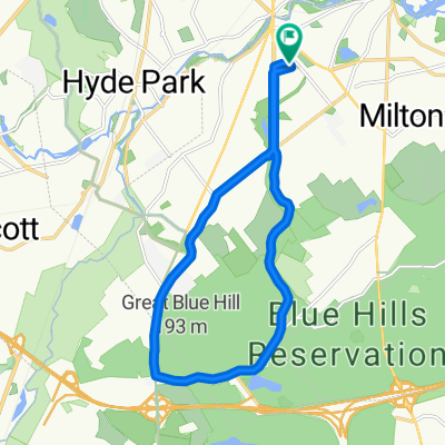
East Milton around Franklin Park
A cycling route starting in Milton, Massachusetts, United States.
Overview
About this route
- -:--
- Duration
- 17.1 km
- Distance
- 118 m
- Ascent
- 119 m
- Descent
- ---
- Avg. speed
- ---
- Max. altitude
Route quality
Waytypes & surfaces along the route
Waytypes
Road
7.5 km
(44 %)
Quiet road
2.6 km
(15 %)
Surfaces
Paved
16.1 km
(94 %)
Unpaved
0.5 km
(3 %)
Asphalt
15.9 km
(93 %)
Gravel
0.5 km
(3 %)
Continue with Bikemap
Use, edit, or download this cycling route
You would like to ride East Milton around Franklin Park or customize it for your own trip? Here is what you can do with this Bikemap route:
Free features
- Save this route as favorite or in collections
- Copy & plan your own version of this route
- Sync your route with Garmin or Wahoo
Premium features
Free trial for 3 days, or one-time payment. More about Bikemap Premium.
- Navigate this route on iOS & Android
- Export a GPX / KML file of this route
- Create your custom printout (try it for free)
- Download this route for offline navigation
Discover more Premium features.
Get Bikemap PremiumFrom our community
Other popular routes starting in Milton
 Neponset River Trail, Boston to Denny St, Boston
- Distance
- 5.6 km
- Ascent
- 16 m
- Descent
- 19 m
- Location
- Milton, Massachusetts, United States
 East Milton around Franklin Park
- Distance
- 17.1 km
- Ascent
- 118 m
- Descent
- 119 m
- Location
- Milton, Massachusetts, United States
 19 Squantum St, Milton to 36 Hull St, Boston
- Distance
- 16.5 km
- Ascent
- 10 m
- Descent
- 0 m
- Location
- Milton, Massachusetts, United States
 Blue Hills 1
- Distance
- 31.2 km
- Ascent
- 307 m
- Descent
- 307 m
- Location
- Milton, Massachusetts, United States
 Hobbits
- Distance
- 8 km
- Ascent
- 75 m
- Descent
- 64 m
- Location
- Milton, Massachusetts, United States
 Moderate route in Boston
- Distance
- 5.4 km
- Ascent
- 0 m
- Descent
- 8 m
- Location
- Milton, Massachusetts, United States
 Blue Hills, Sawcut Notch Path, 4.6km round
- Distance
- 4.6 km
- Ascent
- 83 m
- Descent
- 83 m
- Location
- Milton, Massachusetts, United States
 Blue Hill Loop
- Distance
- 15.2 km
- Ascent
- 142 m
- Descent
- 140 m
- Location
- Milton, Massachusetts, United States
Open it in the app