

Avon Cycleway sections
Bitton to Iron Acton
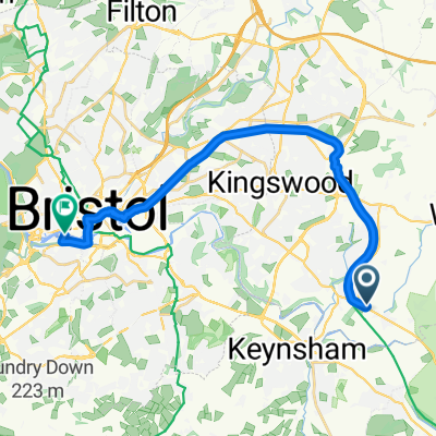
A cycling route starting in Bitton, England, United Kingdom.
Overview
About this route
From the Avon Valley Railway cafe, Bitton, to the White Hart Inn, Iron Acton
- -:--
- Duration
- 16.3 km
- Distance
- 85 m
- Ascent
- 57 m
- Descent
- ---
- Avg. speed
- ---
- Max. altitude

Part of
Avon Cycleway sections
18 stages
Route quality
Waytypes & surfaces along the route
Waytypes
Cycleway
8.8 km
(54 %)
Quiet road
6.5 km
(40 %)
Surfaces
Paved
12.8 km
(79 %)
Asphalt
12.8 km
(79 %)
Undefined
3.4 km
(21 %)
Continue with Bikemap
Use, edit, or download this cycling route
You would like to ride Bitton to Iron Acton or customize it for your own trip? Here is what you can do with this Bikemap route:
Free features
- Save this route as favorite or in collections
- Copy & plan your own version of this route
- Sync your route with Garmin or Wahoo
Premium features
Free trial for 3 days, or one-time payment. More about Bikemap Premium.
- Navigate this route on iOS & Android
- Export a GPX / KML file of this route
- Create your custom printout (try it for free)
- Download this route for offline navigation
Discover more Premium features.
Get Bikemap PremiumFrom our community
Other popular routes starting in Bitton
 Marsh34
- Distance
- 50.2 km
- Ascent
- 536 m
- Descent
- 537 m
- Location
- Bitton, England, United Kingdom
 Marsh13
- Distance
- 33.6 km
- Ascent
- 556 m
- Descent
- 400 m
- Location
- Bitton, England, United Kingdom
 Bristol and Bath Railway Path, Bitton, Bristol to 11A Evenlode Way, Bristol
- Distance
- 6.5 km
- Ascent
- 43 m
- Descent
- 49 m
- Location
- Bitton, England, United Kingdom
 Marsh41
- Distance
- 38.8 km
- Ascent
- 515 m
- Descent
- 358 m
- Location
- Bitton, England, United Kingdom
 35 School Road, Bristol to Church Lane, Monkton Combe, Bath
- Distance
- 434.1 km
- Ascent
- 232 m
- Descent
- 216 m
- Location
- Bitton, England, United Kingdom
 Bitton to Bristol direct
- Distance
- 10.5 km
- Ascent
- 84 m
- Descent
- 97 m
- Location
- Bitton, England, United Kingdom
 Campsite to Bristol
- Distance
- 17.7 km
- Ascent
- 78 m
- Descent
- 89 m
- Location
- Bitton, England, United Kingdom
 Bristol And Bath Railway Path, Bitton to Upper Bristol Road 25
- Distance
- 8.2 km
- Ascent
- 0 m
- Descent
- 3 m
- Location
- Bitton, England, United Kingdom
Open it in the app