

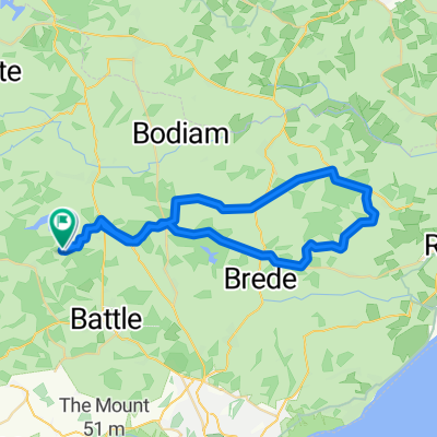
Stonegate
A cycling route starting in Robertsbridge, England, United Kingdom.
Overview
About this route
Great route a few good hills but no pushing or stopping on any of them, oh yeah and a few "false levels" :-) <br />Altitude range 587 feet (Altitude from 33 feet to 620 feet) - Total climb 1,831 feet, Total descent 1,831 feet
- -:--
- Duration
- 38.7 km
- Distance
- 529 m
- Ascent
- 531 m
- Descent
- ---
- Avg. speed
- ---
- Max. altitude

Continue with Bikemap
Use, edit, or download this cycling route
You would like to ride Stonegate or customize it for your own trip? Here is what you can do with this Bikemap route:
Free features
- Save this route as favorite or in collections
- Copy & plan your own version of this route
- Sync your route with Garmin or Wahoo
Premium features
Free trial for 3 days, or one-time payment. More about Bikemap Premium.
- Navigate this route on iOS & Android
- Export a GPX / KML file of this route
- Create your custom printout (try it for free)
- Download this route for offline navigation
Discover more Premium features.
Get Bikemap PremiumFrom our community
Other popular routes starting in Robertsbridge
 Peasmarsh without the hill
- Distance
- 45.3 km
- Ascent
- 367 m
- Descent
- 358 m
- Location
- Robertsbridge, England, United Kingdom
 Bodiam (via Virgin Lane)
- Distance
- 37 km
- Ascent
- 353 m
- Descent
- 353 m
- Location
- Robertsbridge, England, United Kingdom
 L2B training
- Distance
- 65.9 km
- Ascent
- 402 m
- Descent
- 402 m
- Location
- Robertsbridge, England, United Kingdom
 Stonegate
- Distance
- 38.7 km
- Ascent
- 529 m
- Descent
- 531 m
- Location
- Robertsbridge, England, United Kingdom
 Bodle Street Green
- Distance
- 33.7 km
- Ascent
- 401 m
- Descent
- 401 m
- Location
- Robertsbridge, England, United Kingdom
 From Robertsbridge to Amsterdam
- Distance
- 558.1 km
- Ascent
- 1,358 m
- Descent
- 1,407 m
- Location
- Robertsbridge, England, United Kingdom
 Step 1 Robertsbridge to Folkestone Station
- Distance
- 85.1 km
- Ascent
- 795 m
- Descent
- 802 m
- Location
- Robertsbridge, England, United Kingdom
 Rye and Winchelsea
- Distance
- 56.9 km
- Ascent
- 419 m
- Descent
- 419 m
- Location
- Robertsbridge, England, United Kingdom
Open it in the app